A bay belonging to the Indian Ocean. It is embedded in Sri Lanka (Ceylon) to the west, India to the north, Myanmar and the Andaman-Nicobar Ridge to the east, and the line connecting Cape Dondela at the southern end of Sri Lanka and Cape Urellue at the northwest end of Sumatra to the south. boundary. The southern border is approximately 1,609 kilometers long. The part of the Andaman-Nicobar Ridge that emerges from the sea, with the Andaman Islands in the north and the Nicobar Islands in the south, separates the Bay of Bengal from the Andaman Sea in the east. At the top of the bay are the giant deltas of the Ganges and Brahmaputra rivers. Other rivers flowing into the bay are the Mahanadi, Godavari and Krishna rivers in India. The Bay of Bengal (named after the Indian state of Mongolia) has a total area of 2.172 million square kilometers, a total volume of 5.616 million cubic kilometers, and an average water depth of 2,586 meters.
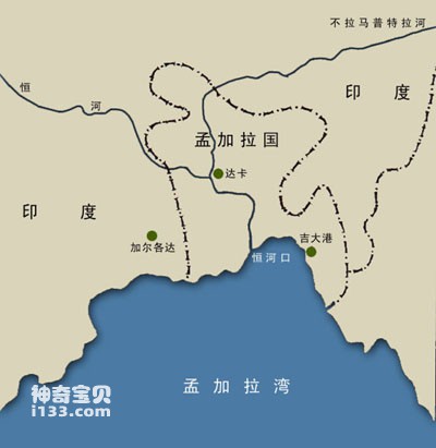
Geographical map of the Bay of Bengal
The continental shelf of the Bay of Bengal is 161 kilometers wide, wider in the north and east. The average depth of the continental shelf on the seaward side is 183 meters. Most of the continental shelf is composed of sand, and the seaward side is mostly clay and soft mud. It is cut by submarine canyons in several places. Among them are the Ganges Canyon, located outside the Ganges-Brahmaputra Delta, with a depth of 732 meters; Andhra, Krishna and Mahadevan Canyons are located on the western edge of the bay.

People along the Bay of Bengal are used to fishing while sitting on wooden piles
The deep-sea disk of the Bay of Bengal is roughly U-shaped, with a depth of 4,500 meters. The basin floor has two features: in the north there is a very straight, 5000 km long east longitude 90. and the Ganges delta, formed by alluvial sediments from the continental shelf. Longitude 90. At the top of the ridge, the water depth is about 2134 meters, and its northern end is covered with sediments from the Ganges Delta. The delta is dotted with dendritic gullies (fan valleys). This allows sediments to be transported to distant deep ocean basins.
The surface circulation in the Bay of Bengal is strongly affected by the monsoon. In spring and summer, moist southwesterly winds cause clockwise circulation. In autumn and winter, due to the influence of northeasterly winds, they change into counterclockwise circulation. Due to the topographic effect of the Bay of Bengal, various forces are focused. Therefore, phenomena such as tidal range, static vibration and internal waves are all significant.
animal tags:
We created this article in conjunction with AI technology, then made sure it was fact-checked and edited by a Animals Top editor.
you may also like

The origin of life has always been a subject of research by scientists. Judging from current research results, it is generally believed that life originated in the ocean. Water is an important component of life activities, and the protection of seawater can effectively prevent ultraviolet ray...

Antarctica, the southernmost continent on Earth, spans approximately 14 million square kilometers. It is one of the coldest, most remote, and least inhabited places on the planet. Despite its harsh conditions, this frozen continent is home to a surprising number of unique and resilient animal specie...

White star grouper. The body is dark brown and the edge of the dorsal fin is white. There are white spots scattered on the sides of the body, dorsal fin, anal fin and tail fin, but the white spots on the side of the body are connected into irregular wavy markings. Body length 50 cm. Distribut...

Whales (family Balaenidae) are among the largest creatures on Earth and have existed for millions of years. They belong to the group of baleen whales (Mysticeti), which are mammals adapted to aquatic life and possess baleen plates instead of teeth for filtering food.However, in everyday language, th...

Warm seawater near the equator flows to the Arctic and Antarctic seas through circulation, and cold polar water flows to the equatorial seas through circulation, forming the circulation of the world's oceans. Ocean circulation is an important factor in maintaining the earth's heat balance. Th...

On November 15, 1963, 32 kilometers south of Iceland in the North Atlantic, a submarine volcano 130 meters below the sea suddenly erupted, ejecting volcanic ash and water vapor columns hundreds of meters high. At the climax of the eruption, the volcanic ash and smoke were washed up to several...

There are bright red spiny starfish and huge bread starfish in the ocean; there are also beautiful shell-shaped sea urchins with purple-red bodies and beautiful patterns on their petal-like spines. Their spines are thick and vary greatly in color. Making cigarette holders, it is also called "...

There are 25-27 scales in a row of mud fish. The preorbital and infraorbital bones are scaly and have serrated lower edges. There are 3 horizontal bands on the sides of the body. A small warm-water fish that inhabits coral reef areas. Body length is generally 10-52 mm....
Email: jsset668#gmail.com (change # to @) Please indicate your purpose of visit! Guangdong ICP No. 2022053326 XML| map| Chinese
