If there are no clouds in the sky and the sky is high and the air is crisp, you stand on the high point of the central coast of Fujian and look eastward. In the depths of the vast sea, you can vaguely see the island of Taiwan. It is like a beautiful gem set in the jade-like blue waves. Taiwan Island faces the Pacific Ocean to the east and Fujian Province to the west across the sea. It is located southeast of the mainland and is the highest island in my country. The plan shape of Taiwan Island is like a banana leaf, with its long axis running in the north-northeast direction, 394 kilometers long from north to south, 144 kilometers wide at its east-west point, and covering an area of 35,778 square kilometers. The coast of Taiwan Island is straight with few twists and turns, and the coastline is 1,139 kilometers long. The Tropic of Cancer crosses the center of the island, and the sun shines vertically on Taiwan Island around the summer solstice every year. Taiwan Island straddles the subtropical and tropical climate zones. It is the only island in my country with tropical and subtropical scenery, and it is also the largest mainland island in my country. It is famous for its beautiful and colorful Alishan Mountain, Sun Moon Lake and other scenic spots.
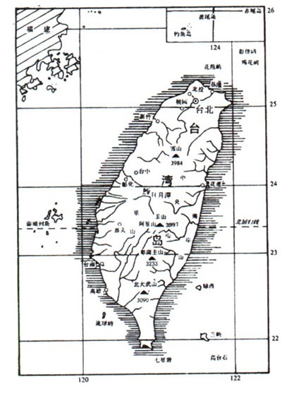
Topographic map of Taiwan Island
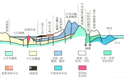
Geological map of Taiwan
The island of Taiwan is surrounded by the sea, and is separated from the mainland by a narrow waterway - the Taiwan Strait. A corridor also connects the East China Sea and the South China Sea. Not only ships from both sides of the Taiwan Strait pass through this, but also ships from Western Europe and the Indian Ocean coastal countries come to Northeast Asia ports. Most of them pass by here. Taiwan Island is located on the east side of the maritime corridor and right between the world's largest Pacific Ocean and the largest Eurasian continent. It has an important strategic position.
Taiwan was called Yizhou in ancient times and has been a territory of China since ancient times.
Jinshan Candlestick Island, located on the coast of Taipei, looks like a pair of candlesticks. There are many hot springs here, rich fisheries, and the natural scenery of the coastal beaches is very good.
It was occupied by the Netherlands in 1624. In 1661, national hero Zheng Chenggong regained Taiwan. In 1683, the Qing government established Taiwan Prefecture, which was changed to Taiwan Province in 1885. Japan invaded Taiwan in 1895. After Japan surrendered in 1945, Taiwan Island and its affiliated islands returned to China.
Looking at the topographic map of Taiwan Island, most of the central and eastern parts of Taiwan Island are brown and yellow. It tells us that Taiwan Island is a mountainous island, about 2/3 of the land is occupied by mountains, and only 1/3 of the area is green plains. If you fly across the island of Taiwan, you can see the mountains in the central and eastern parts, and the flat plains in the west, which is very eye-catching and intuitive. The central and eastern mountains are collectively called the Taiwan Mountains, which are formed by folds and faults. Bounded by the Taitung Longitudinal Valley, the Taiwan Mountains are divided into two major mountain systems, the Taitung Coast Mountains to the east and the Taiwan Mountains to the west, which include the Central Mountains, the Snow Mountain-Yushan Mountains and the Ali Mountains. Topographically, the Central Mountain Range divides Taiwan into two asymmetrical halves, with steep slopes in the east and gentle slopes in the west. From the ridge of the Central Mountains to the west, there are high mountains, medium and low mountains, hills, mesas, and then plains, which are connected to the sea; To the east is the Taitung Longitudinal Valley, middle and low mountains, and then goes straight down to the deep sea, forming four mountain ranges. A longitudinal valley and a plain are arranged vertically and parallel to each other in an orderly and special landform. There are also intermountain plains among the mountains, called basins. Taiwan Island includes all landform types on the mainland.
The Central Mountain Range, with steep and straight peaks and screen-like peaks, stretches continuously, with most altitudes above 3,000 meters. It has become the backbone of Taiwan and the watershed between the east and the west.
Taitung Coast Mountain Range has an average altitude of 1,000 meters above sea level. It is higher in the south and lower in the north. The highest is 1,682 meters (Xingang Mountain) and the lowest is only about 500 meters. It is connected to the Pacific Ocean in the east, and its coast is as steep as a wall, rising up to 1,000 meters above the sea. It is a famous cliff coastal zone in my country.
To the west of the Central Mountain Range is the Snow Mountain-Yushan Mountain Range. It has many peaks and peaks. There are 7 peaks above 3,800 meters above sea level on the island, 5 of which are located in the Yushan Mountains. The main peak, Yushan, is 3,997 meters high and is the highest peak on the southeast coast of my country.
The Ali Mountain Range runs through the western part of Taiwan, with heights ranging from 1,000 to 2,500 meters. The mountains are gentle and the peaks are winding. Near the main peak, Data Mountain, is a famous scenic spot with dense forests and rich red juniper trees. There are ancient red juniper trees that are more than 3,000 years old and are known as the "sacred trees".
The western plain of Taiwan Island is formed by alluvial rivers. It is narrow in the north and wide in the south, and is about 40 to 50 kilometers wide. It consists of two major plains, Tainan and Pingtung. The west coast of Taiwan Island is a sandy coast that stretches from land to sea by about 15 meters every year. Between the hills and mountains there are two basins, Taichung and Taipei.
animal tags:
We created this article in conjunction with AI technology, then made sure it was fact-checked and edited by a Animals Top editor.
you may also like

On the southern coast of the Mediterranean Sea, there is a place called Tunisia. In the nearby Madia Sea area, 40 meters underwater, many marble columns were found buried in the mud. According to historians, they are cultural relics from 2,000 years ago. After the discovery was announced, Aus...
")
The Wandering Albatross is the largest flying crow in Antarctica and the king of flying birds in the world. It is covered in pure white feathers with black markings on its tail and wing tips. Its body is streamlined. When it spreads its wings and flies, the distance between the wing tips can...

Coasts made of hard rock are called bedrock coasts. It has clear outlines, strong lines and majestic momentum. It not only has masculine beauty, but also has an ever-changing charm. It is one of the main types of coast. Sea stack bedrock coasts often have protruding headlands, and between the...
")
Between the island of Great Britain and the European continent, there is a waterway connecting the Atlantic Ocean and the North Sea, which is the famous English Channel and the Strait of Dover. These two straits are actually one, but historically they have been divided into two straits, bound...

Dugong There is a kind of sea beast called dugong living along the coasts of Guangdong, Guangxi, Taiwan and other provinces in my country. Its name is a direct transliteration of Malay, and some people also call it "Southern Sea Cow". In addition to China, dugongs are also distributed in s...

Eyes The fish body is very flat on the side, shaped like a lens. The ventral edge is very convex and thin. The mouth is small and almost vertical. The base of the hip road is long, with 2 spines and 38-33 fin rays when the fish is young; when the fish is large, the spines disappear, and most...

The eyes of the poisonous scorpionfish are small and dorsal, with a deep depression under the eyes. Vomerus. The dorsal fin spines are covered with thick skin and have venom sacs at the base. There are no free fins below the pectoral fins. Warm water bottom fish, often hi...

From the appearance, the leaf fish looks exactly like a leaf. It can adapt to its environment and change color, so it can sneak up on its prey. Its mouth opens wide and it can swallow very large fish....
Email: jsset668#gmail.com (change # to @) Please indicate your purpose of visit! Guangdong ICP No. 2022053326 XML| map| Chinese
