The Dardanelles Strait is located on the west side of the northwest corner of Turkey. It is an important channel connecting the Sea of Marmara and the Aegean Sea. The total length of the strait is 71 kilometers, the narrowest point is only 1.3 kilometers, the widest is 7.5 kilometers, and the shallowest point is 53 meters deep. , the deepest water depth is 106 meters.
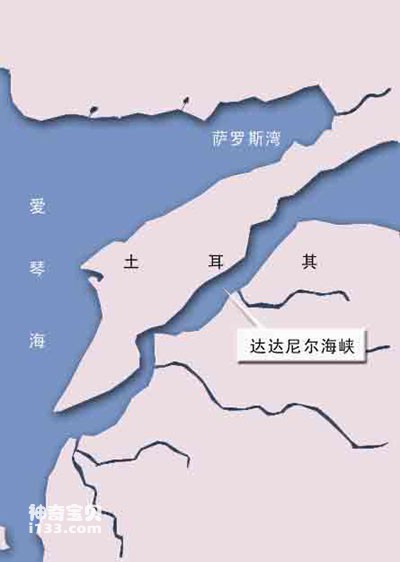
Geographic location map of the Dardanelles Strait
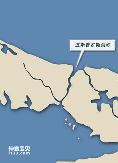
Geographical location map of the Bosporus
The Bosporus is located on the north side of the northwest corner of Turkey. It is an important channel connecting the Sea of Marmara and the Black Sea. The Bosporus is about 30 kilometers long, with a narrowest point of 800 meters and a maximum width of 2,400 meters. The shallow point is 27.5 meters and the deepest is 80 meters.
The Bosporus Strait and the Dardanelles Strait together form the channel for countries along the Caspian Sea to enter and exit the open sea.
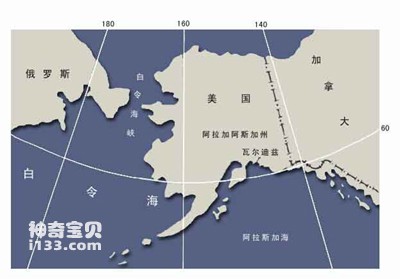
Geographical map of the Bering Strait
The Bering Strait is located at the northeastern tip of Asia and the northwest tip of North America. It connects the Arctic Ocean and the Pacific Ocean, and separates Siberia in Asia and Alaska in North America. It has a width of 35 to 86 kilometers and a depth of 42 meters. However, this was not the case here before.
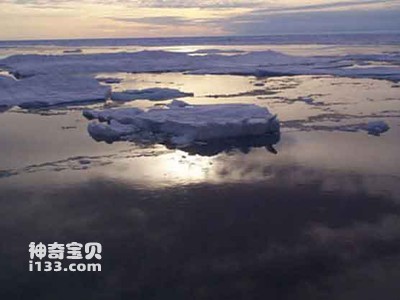
Ice floes in the Bering Strait
During the Ice Age, the northern hemisphere was covered by glaciers, and these huge ice blocks accumulated a large amount of water on the earth. During the coldest period of the ice age, the water level of the Bering Sea dropped by more than 90 meters. The land above the water forms a "bridge" that connects the two continents. This is the Bering Sea Land Bridge. During that period, many animals from Eurasia entered the Americas via land bridges. Archaeologists believe that the ancestors of the Indians were hunters who passed through this land bridge to North America while tracking their herds.
After crossing the land bridge, they were not able to enter the hinterland of America immediately. This is because it was in the Ice Age at that time, and the entire North American continent was covered with ice. At the coldest time, the thickness of this ice once reached 1.6 kilometers. In some different historical periods, the climate changed. Sometimes the weather became warmer, and a passage appeared between the two major glaciers in North America. Then they gradually reached the central and southern parts of North America. Settled there.
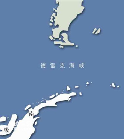
Drake Passage
The Drake Strait is located between the southernmost tip of South America and Antarctica, close to Chile and Argentina. It is an important strait for the communication between the Atlantic Ocean and the Pacific Ocean in the south. The total length is 900 kilometers, the narrowest point is 890 kilometers, the maximum depth is 5248 meters, and the minimum depth is 80 meters.
animal tags:
We created this article in conjunction with AI technology, then made sure it was fact-checked and edited by a Animals Top editor.
you may also like

Sea turtles belong to two main families: Cheloniidae and Dermochelyidae. Within these groups, we find the green turtle, loggerhead turtle, olive ridley turtle, hawksbill turtle, flatback turtle, Kemp’s ridley turtle, and leatherback turtle.They are among the most fascinating reptiles of the oceans,...
")
There are three dorsal fins on the back and a small beard on the mouth, which are typical characteristics of cod. In northern my country, cod is called "big head fish" or "big head fish", while in North Korea, cod is called "pollen fish". Cod is full of treasures. In addi...

In front of the dorsal line of the white-striped sawfish, there is a broad milky-white band surrounded by a narrow black edge that extends diagonally downward, passing through the posterior edge of the eye and reaching the back of the interopercular bone. It is a small warm-water fish that li...
")
Among the Antarctic seagulls, there is a kind of brown seagull called the skua. From its name, you will know that it is probably not a good thing. Some people call it an air bandit, which is not an exaggeration at all. Although its appearance is not very ugly, with clean brown feathers, a thi...

Glowing jellyfish mainly refers to fluorescent jellyfish (Jellyfish), some of which have the ability to emit light. Fluorescent jellyfish emit light using a chemical reaction called bioluminescence, which produces light through oxidase, luciferin, and oxygen molecules.Here are some common glowing je...

In the blue ocean, there are many beautiful and transparent jellyfish living in it. They float in the sea like parachutes one by one, and their graceful appearance is amazing. The sky-blue sail jellyfish has a transparent "sail" erected on its back, which is bumpy in the sea like a small boat...

Peru is located on the southeast coast of the Pacific Ocean, with a coastline of more than 2,200 kilometers. The coast of Peru is a famous fishing ground in the world. In the 1950s, Peru's fishery output reached hundreds of thousands of tons. After 1962, the fishery developed even faster, wit...

Coelenterates are taxonomically lower metazoans. Cnidocytes are unique to coelenterates. They are located all over the body surface and are especially numerous on the tentacles. Therefore, coelenterates are also called cnidarians. Currently, a total of 1,010 species of va...
Email: jsset668#gmail.com (change # to @) Please indicate your purpose of visit! Guangdong ICP No. 2022053326 XML| map| Chinese
