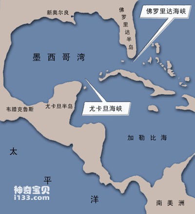
On the southeastern edge of North America, there is an oblate gulf, named the Gulf of Mexico because it borders Mexico. The east and north of the Gulf are the United States, the west and south shores are Mexico, and the southeastern sea is Cuba. The Gulf of Mexico enters the Atlantic Ocean through the Florida Straits and is connected to the Caribbean Sea through the Yucatan Strait. It covers an area of about 1.5 million square kilometers. The average water depth is about 1,500 meters, and the deepest point is more than 5,000 meters.
Location map of the Gulf of Mexico
There are many twists and turns along the bay, and there are many swamps, shoals and mangroves on the shore. There are continental shelves, continental slopes and abyssal plains on the seabed. The famous Mississippi River flows into the north shore, bringing a large amount of sediment into the bay, forming a huge estuary delta. In the Yucatan Strait, there is a sill, about 1,600 meters below the sea surface, which serves as the boundary between the Gulf of Mexico and the Caribbean Sea.
The Gulf of Mexico is located in the tropics and subtropics, with high temperatures and rainy weather. The highest temperature is in August, which can reach over 28°C. The lowest temperature is in February, which is about 12°C in the north and 22°C in the south. There are often northerly winds in winter and typhoons in summer. There is a lot of precipitation, with an annual average of about 1,500 millimeters.

Ships anchored in Gulf of Mexico ports
The Gulf of Mexico gathers part of the North Equatorial Current and the South Equatorial Current, and also receives warm Atlantic water that is constantly driven in by the trade winds, making the water level in the bay much higher than the nearby sea surface, and turning the bay into a huge hot water reservoir. Warm water in the bay flows out of the Florida Straits and becomes an important source of the Mexican Warm Current. The Gulf Stream is the world's largest warm current, and the amount of hot water it carries is 120 times the total amount of all rivers in the world. It is estimated that the heat transported by the Gulf Stream to the coast of northwest Europe every year is equivalent to the heat released by burning 6 million tons of coal per kilometer, making the climate in northwest Europe warm and humid without severe cold in winter. The Gulf of Mexico on the west side of the Atlantic Ocean brought such great benefits to Europe on the east side of the Atlantic Ocean, but they themselves did not know it at first. Later, in the early 20th century, the mystery was solved by oceanographers.
The tide in the Gulf of Mexico is a diurnal tide that rises and falls every day; the tidal range is generally very small. Only during the typhoon season, the tide is driven by the typhoon, causing the sea water to rise sharply and become a storm surge. The water level is sometimes as high as 5 meters, which can cause serious damage to the coast. Depressions pose a threat, especially on the north shore of the bay where storm surges are high.
The Florida Peninsula on the Gulf of Mexico coast is more than 600 kilometers long from north to south and 200 kilometers wide from east to west. When the Spaniard Ponce de Leon discovered the peninsula, he saw the peninsula was blooming and colorful, so he named it "Florida", which means "flowers" in Spanish. This is the warmest place in the United States, and the coldest winter is only 15°C. It is a popular place to escape the cold and visit. The Mayan Mountains of the Yucatan Peninsula were once the birthplace of Indian culture. There are huge pyramids preserved here, which are comparable to those in Egypt.
animal tags:
We created this article in conjunction with AI technology, then made sure it was fact-checked and edited by a Animals Top editor.
you may also like

The common name of French crappie: French crappie. The kiss stands out. The front rays of the dorsal and anal fins are long filaments. The body is dark brown with several yellow arc stripes and golden yellow between the scales. There is a yellow spot at the base of the pectoral fin. Caudal fi...

Marine fish and various marine animals all feed on plankton, the tiny plants and animals floating in the sea, just like we humans feed on food produced in agriculture and livestock produced in animal husbandry. Marine plankton is an important part of marine life. They are large in number and...

The side of the body of the Forked Butterflyfish is flat and high. The kiss is short. The body is weakly lamellar and the lateral line is incomplete. There is a black horizontal band on the head, and there are many brown vertical stripes along the body side. There are often bifurcations at th...

The body of the white-edged serrated fish is strongly combed, with 30 lateral line scales. There are no long spines on the lower back corner of the front gill cover, and the ribs on the top of the head are smooth. The rays of the odd fin and the front edge of the pelvic fin are milky white, a...

Among the incredible biodiversity of marine ecosystems, one group of fish stands out for its seemingly magical ability to soar above the sea: the flying fish. While they don't truly fly like birds, these remarkable creatures can leap out of the water and glide through the air for impressive dist...

Humpback whale aliases: big-winged whale, humpback whale, saw-armed whale. The body is hypertrophic, with a broad upper trunk. There are tumor-like protrusions along the central line from the breathing hole to the tip of the snout, as well as on both sides of the upper and lower whiskers. The...

The box jellyfish (Chironex fleckeri) is considered one of the most venomous creatures on Earth. A single individual contains enough venom to kill up to 600 people. Since 1954, this species has been linked to over 5,500 human fatalities. Its deadly nature has even been portrayed in films, often as a...
")
There are 18 species of penguins living in the world, including little white-fingered penguins, white-fingered penguins, yellow-eyed penguins, Magellanic penguins, Peruvian penguins, Galapagos penguins, emperor penguins, king penguins, Adrien penguins, and Antarctic penguins. , gentoo penguin...
Email: jsset668#gmail.com (change # to @) Please indicate your purpose of visit! Guangdong ICP No. 2022053326 XML| map| Chinese
-Animals Top")