A marginal sea in the western Pacific. It is bounded by Japan's three major islands (Kyushu, Honshu and Hokkaido) to the east; North Korea to the west and southwest; and the Soviet Union to the north and northwest. The Soya Strait is connected to the Sea of Okhotsk in the northeast; it is connected to the Pacific Ocean via the Tsugaru Strait between Honshu and Hokkaido. In the south, it is connected to the Yellow Sea and the East China Sea through the Korean Strait. The total area of the Sea of Japan is 978,000 square kilometers, the average water depth is 1,752 meters, and the volume is 1.713 million cubic kilometers. The maximum water depth found in the Japan Sea Basin is 4049 meters.
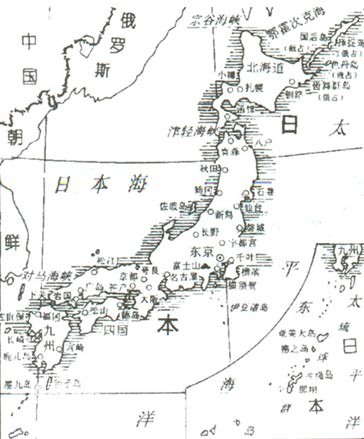
Geographical map of the Sea of Japan
People in ancient times might have been able to cross what is now the Sea of Japan on foot. There is evidence that during the period of low sea level following the last glacial period (11,000-8,000 years ago), both the Korea Strait and the Soya Strait were exposed and could serve as a land bridge from Japan to the Asian continent. Fossil remains of Indian Elephants-Are-Endangered.html">elephants have been found on islands in southern Japan, and fossil remains of woolly mammoths have been found in northern Japan. Similar phenomena indicate that people from China, Korea and Siberia migrated to Japan in ancient times.
The written history of Japan begins with J. Tanno in 660 BC. He occupied the main island of Honshu and became the first emperor of Japan. In 550 AD, a Korean Buddhist sailed to Japan, bringing various cultures and written languages with him, but it was not until Portuguese sailors landed here in 1543 that Japan became famous in Europe, although in the late 13th century, Marco Pole When Luo returned from China, he brought back a report about the presence of Japan. Despite this, until 1660, no good map of the Sea of Japan had been published, and even the name "Sea of Japan" commonly used today did not come into existence until 1815. This is the Russian navigator A. J. v. The name given to this sea by Crussenstedt.
The continental shelf of the Sea of Japan is short and poorly developed. Along the west coast of Japan, the continental shelf ends at a water depth of 200 meters, and on the east coast of North Korea and the Soviet Union, the continental shelf ends at a water depth of 140 meters. These continental shelves are cut by numerous submarine canyons. On the western edge, the mouth end of the canyon extends to a depth of nearly 2,000 meters; on the eastern edge, the mouth end of the canyon extends to a depth of nearly 800 meters.
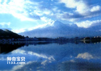
Mount Fuji located in the Sea of Japan
The most obvious feature of the Japan Sea deep-sea basin is that in the northern and northwest half of the sea, the water depth is greater than 3,000 meters. The featureless sea basin is called the Japan Sea Basin. Going south from this basin is more complicated. The seabed is separated by Yamatodui and Shupu shoals, and there is a deep sea trough between the two shoals. There are also some islands scattered locally on the seabed in the south, such as Tsushima Islands in the Korean Strait, Ogi Islands on the west coast of southern Honshu, and Ulleungdo Island off the coast of Korea.
The main current in the Sea of Japan is the Tsushima Warm Current, which flows northward. It separates from the Kuroshio Current and flows into the Sea of Japan through the Korean Strait. The branch of the Tsushima Warm Current is called the East Korea Warm Current, which goes north along the coast of North Korea, then turns east, and then merges with the Tsushima Warm Current. The Tsushima Warm Current finally flows into the Pacific Ocean through the Tsugaru Strait (Ritsugaru Warm Current). It flows into the Sea of Okhotsk through Soya Strait (Soya Warm Current). In addition, there are three unique cold currents in the Sea of Japan (North Korean cold current, offshore cold current and central Sea of Japan cold current). These cold currents flow from north to south and mix with warm currents in the central part of the Sea of Japan.
The northern part of the Sea of Japan, especially along the Siberian coast, began to freeze in November. The ice area expanded to the middle of the sea in mid-February, causing serious obstacles to navigation. In May, all waters are ice-free.
Like all nearly closed seas, the tides in the Sea of Japan are extremely small. The tidal range along the coast of Japan is only 0.2 meters, and that of the Siberian coast is 0.4-0.5 meters. The Korean Strait, adjacent to the Yellow Sea and the East China Sea, has a tidal range of approximately 2 meters.
animal tags:
We created this article in conjunction with AI technology, then made sure it was fact-checked and edited by a Animals Top editor.
you may also like
")
There are three dorsal fins on the back and a small beard on the mouth, which are typical characteristics of cod. In northern my country, cod is called "big head fish" or "big head fish", while in North Korea, cod is called "pollen fish". Cod is full of treasures. In addi...

Nowadays, there are many kinds of pets, and the number of people who keep crabs as pets is also increasing day by day. Compared with ornamental shrimps, the cultivation of ornamental crabs is relatively simple, so they are very popular. For beginners, there are many choices for ornamental crabs that...

The silky butterfly fish has an oval body with very flat sides. The snout is long and conical. The dorsal fin has a filamentous extension ray, and there is an eye-shaped spot below it that is larger than the diameter of the eye. There is a horizontal band on the side of the head that passes t...

The humpback whale is a toothed whale that belongs to the suborder Mysticeti. It is usually called a "humpback whale" and its scientific name is Balaenoptera physalus. The suborder Baleen whales refers to those mammals that belong to the order Artiodactyla cetaceans, also known as the order B...

Mangrove is a forest that grows in seawater. It is a unique forest vegetation growing in tropical and subtropical coasts and intertidal zones of estuaries. Their root systems are very developed, and they stand intertwined in the tidal flats. They have leathery green leaves that are shiny. Lik...

Coral polyps live in warm oceans and are crowded and fixed on rocks. New corals grow on the skeletons of dead corals, and some form branch-like branches with delicate and flexible branches. The shapes of the corals are beautiful and diverse: there are staghorn corals that look like antlers; t...

Bigger has advantages, at least in ancient oceans. Professor Marc Laflamme from the University of Toronto Mississauga campus explained why ancient organisms tended to become larger. For early multicellular organisms, size was really a huge advantage. In order to apply NASA's Space Institute r...

The vaquita (Phocoena sinus), also known as the “little sea cow” or “cochito,” is the rarest marine mammal in the world and one of the most endangered. Endemic to the northern part of the Gulf of California, Mexico, the vaquita’s population has plummeted in recent decades. Today, it is estimate...
Email: jsset668#gmail.com (change # to @) Please indicate your purpose of visit! Guangdong ICP No. 2022053326 XML| map| Chinese
