The continental shelf is a natural extension of the continent. The slope is generally small and there are not many fluctuations. The total area of the world's continental shelves is approximately more than 27 million square kilometers, with an average width of approximately 75 kilometers, accounting for 8% of the total ocean area. The shallow seas on the continental shelf are close to human settlements and have the closest relationship with humans. About 90% of the fishery resources come from the shallow seas on the continental shelf. Since ancient times, human beings have fished, caught crabs and traveled to the sea here, enjoying the "benefits of fish and salt and the convenience of boating". With the development of production, people opened bathing beaches, exploited oil, and used the sunshine, beaches and fresh air to develop tourist resorts.

Coast photos
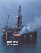
Oil derricks standing on the continental shelf
On the bottom of many shallow seas, winding underwater valleys can be found. What is interesting is that they can often correspond to river valleys on land. The Hudson Underwater River Valley in North America is very obvious. It extends to the bottom of the Atlantic Ocean along the southeast direction. The top is a shallow flat semicircle, which gradually becomes deeper "downstream". The deepest point is 100 meters below the sea surface. The depth of the seabed on both sides of the valley is only 40 meters. The lower outlet of the Hudson River Valley spreads out in a triangular shape, like the wide mouth of a river where it empties into the sea. In Southeast Asia, on the Sunda continental shelf between Sumatra and Kalimantan, there is a dendritic underwater valley system. One flows northward and the other flows southward. The submarine "watershed" of the two underwater valleys is Two slightly convex seafloor highlands. The bottoms of these two underwater valleys slowly slope downstream, and their cross sections and plane shapes are exactly the same as those on land. In addition, there are several extremely obvious underwater valleys on the shallow sea floor of a vast continental shelf surrounding the British Isles in northwest Europe. On the current map, the Elbe, Rhine, and Weser rivers all enter the sea separately. If their respective underwater valleys are connected, we can see that after entering the sea, they pass through their respective submarine valleys, extend northward, and finally The three river valleys merge into the North Sea. Many of the rivers flowing into the Atlantic Ocean from France and England are connected to underwater valleys on the seabed. Even the English Channel itself is an undersea valley leading to the Atlantic Ocean.
Why do they resemble river valleys on land so much? This is closely related to the formation of the continental shelf.
It turns out that the continental shelf was once part of the land. However, due to changes in sea level, this part of the land edge was submerged below the sea surface for a period of time and became a shallow sea environment.
Stretching outward from the continental shelf, the seafloor suddenly drops, forming a steep slope. This slope is called the continental slope. It is like the wall of a basin, and like a long belt wrapped around the ocean floor. The width of the continental slope varies in each ocean, ranging from a dozen kilometers to hundreds of kilometers, with an average width of about 70 kilometers. The slope ranges from a few degrees to more than 20 degrees, with an average of 4°30′. It is the longest and most spectacular slope on earth. The global continental slope has a total area of about 28 million square kilometers, accounting for about 12% of the total ocean area. There are many very deep canyons across the slopes, called submarine canyons, which are both deeper and larger than the mountain canyons on land that pass through the mountains.
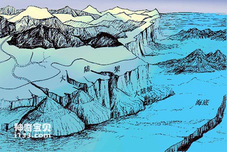
Schematic diagram of continental slope and submarine canyon
According to the terrain characteristics, there are two types of continental slopes. One is a relatively simple terrain with a relatively uniform slope, such as the continental slopes along the North Atlantic Ocean in North America, Europe, and the Barents Sea. The upper half of this type of continental slope is a steep wall, with exposed rocks and lack of sediment. About 2,000 meters down, the slope of the continental slope suddenly becomes very gentle, and the depth gradually increases, becoming an upward concave foothill zone. Along the slope of the continental slope, there are a series of "submarine canyons" parallel to each other, cutting the continental slope. Another kind of continental slope, with complex terrain and many uneven terrains on the slope, is mainly distributed in the Pacific Ocean. The continental slope of the South China Sea belongs to this category. The slope often presents a series of steps, consisting of some angular highlands with flat tops and steep walls, alternating with some closed flat-bottomed depressions. There are some coarse gravel chips on the flat-topped highlands, while some messy sand, stones and soft mud are accumulated in the flat-bottomed depressions. The bottoms of submarine canyons on such continental slopes are also stepped. In addition to these two categories, the continental slopes outside the mouths of large rivers are often relatively flat, and the entire slope is covered with sediment brought from the river.
The sediments on the continental slope mainly come from the continent. The sediment brought into the sea by rivers is transported to the continental slope through the continental shelf. In addition, there is also a considerable part of the ooze that is the remains of marine life. In summary, about 25% of the entire continental slope is covered with sand and 10% is exposed rock. The remaining 65% is covered with a bluish-gray organic ooze. This ooze, often maroon in color due to oxidation, accumulates much more slowly than on continental shelves. In areas with volcanic activity, the soft mud is mixed with volcanic ash, and in high latitudes it is mixed with stones and coarse sand brought by continental flow. Near the mouth of a tropical river, there is a red ooze composed of tropical red weathered soil.
The most special terrain on the continental slope is the deep canyon, called a submarine canyon. It is generally linear, and the valley bottom slope is much greater than that of mountain rivers. The two walls of the canyon are stepped steep walls, and the cross-section is "V" shaped. The scale of submarine canyons is often larger than the grand canyons of rivers on land. The Three Gorges of the Yangtze River in my country is a world-famous grand canyon. The height difference between the two sides of the canyon is nearly 800 meters. There is a steep wall nearly 100 meters high at the bottom, forming a box-shaped canyon at the bottom of the valley. This steep wall is the result of the uplift of the crust in the Three Gorges area during the latest geological period, causing the erosion of the Yangtze River channel. It is formed by an undercut, so when people sail in the Three Gorges, the first thing that impresses people is the vertical steep walls on both sides of the river, which restrict the flow of the Yangtze River between the one to two hundred meter wide rock walls. This is caused by the neotectonic movement of the earth's crust. The Grand Canyon of the United States is also a world-famous grand canyon. The Colorado River cuts through the Mesozoic sandstone formation. The rock walls on both sides are nearly 1,000 meters high. The two walls of the canyon are in the shape of steps, with layers narrowing to the bottom of the valley. There is also a layer formed by the latest tectonic movements. The Colorado River currently flows through this steep-walled canyon. There are not many magnificent canyons like the Three Gorges of the Yangtze River and the Grand Canyon of the Colorado on the mainland. Submarine canyons are much larger than the grand canyons on land. Hundreds of submarine canyons have been discovered, distributed on continents around the world.
Most submarine canyons only exist for a section on the continental slope. They disappear when they go up to the continental shelf and go down to the ocean floor. They have nothing to do with rivers on land. But there are also submarine canyons that can be connected to rivers on land. Like the Hudson Submarine Canyon on the east coast of North America, its source is the Hudson River, which flows into the ocean. There is a shallow underwater valley on the seabed of the continental shelf. The depth is 30 meters below the seafloor, but the width is 7 kilometers. To the edge of the continental shelf, the depth of this underwater valley (below the seafloor) is 40 meters, and the width of the valley reaches 25 meters. Kilometers, it is obvious that the underwater valley is a straight, shallow and flat depression on the continental shelf. Connected to this underwater valley is a submarine canyon on the continental slope, which starts from the top with a water depth of 150 meters and goes down the continental slope to the ocean floor at a depth of 2,400 meters. The depth of its incision on the seafloor is almost more than 1,000 meters in the entire submarine canyon. After its tail end enters the ocean floor at a depth of more than 2,000 meters, it gradually disappears.
animal tags:
We created this article in conjunction with AI technology, then made sure it was fact-checked and edited by a Animals Top editor.
you may also like

Sea cucumbers are marine invertebrates, specifically echinoderms, belonging to the class Holothuroidea. Their characteristics include a robust, worm-like appearance, exposed tentacles, and tube feet surrounding their bodies. Reproduction varies greatly between species and can be sexual or asexual, w...
")
Belugas and dolphins are both very intelligent marine mammals. They belong to the order Cetaceans and Toothed Cetaceans respectively. They have similar social behaviors and complex cognitive abilities. There is no clear conclusion about their IQ, but some comparisons can be made about their c...

Both eyes of the flounder are on the left side of the head. The eye side is dark brown and covered with comb scales; the eye side is white and covered with round scales. The mouth is large, and the clefts on both sides are equal in length. Each of the upper and lower jaws has a row of large c...

In the distant Antarctic and North Pole, what comes into view is the vast ice caps and snowfields, where is the world of ice and snow. The coasts of Antarctica and the Arctic Ocean are very unique. It is difficult to see sand, sand, and rocks there. Instead, the coast is made up of crystal cl...

In the vast ocean, sharks known as "Kings of the Sea" are found all over the world's oceans, and there are more than 70 species in the China Sea (about 350 species in the world). Most sharks are beneficial to humans but not harmful, and there are only more than 30 species. Sharks attack peopl...

The silky butterfly fish has an oval body with very flat sides. The snout is long and conical. The dorsal fin has a filamentous extension ray, and there is an eye-shaped spot below it that is larger than the diameter of the eye. There is a horizontal band on the side of the head that passes t...

An old navigator once said: "The islands in the ocean are like the stars in the sky, no one can count them." This sentence describes the large number of islands in the world. So far, how many islands are there in the oceans around the world? It's hard to tell an exact number. Some people say...

The butterfly fish has a small mouth and a prominent snout. The dorsal fin has powerful spines, with the fourth spine being the longest. The anal fin has three strong spines. There is a large round blue spot with a white edge on the front and lower part of the dorsal fin ray. There are 4 yell...
Email: jsset668#gmail.com (change # to @) Please indicate your purpose of visit! Guangdong ICP No. 2022053326 XML| map| Chinese
