The Gulf Stream is the largest warm current in the world. It is formed by the convergence of the North Equatorial Current and the South Equatorial Current in the Atlantic Ocean that cross the equator. It originates in the Gulf of Mexico. The Atlantic tropical warm water that is constantly driven in by the north and south equatorial currents and trade winds gathers there. The water level is higher than other nearby sea surfaces, becoming a hot water reservoir in the Atlantic Ocean. Hot water flows out continuously from here, feeding the Gulf Stream northward, then turning northeast and reaching the northern European coast.
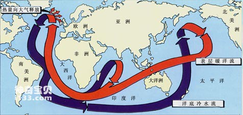
Schematic diagram of the interactive flow direction of warm and cold currents in the global ocean
In the winter in the north, every house has a heating pipe or stove. Otherwise, the cold climate will make people's lives difficult and their work affected. However, artificial heating consumes energy and is very expensive; the stove is also very dirty.
The warm currents on the ocean are free natural heating pipes installed by nature for humans. The Kuroshio Current and East Australian Warm Current in the Pacific; the Gulf Stream and the Brazilian Warm Current in the Atlantic Ocean are all currents that smell cold and bring warmth. As we all know, the climate at the Earth's poles is extremely cold, while the climate near the equator is very hot. Without the regulation of the ocean and atmosphere, the difference between hot and cold would be even greater. According to research by scientists, ocean warm currents play an important role in regulating global climate. They take away excess heat from the equatorial seas and send it to places with cold climates at high latitudes, playing a balancing and mitigating role in changing the global unevenness of heat and cold. They regulate the earth's climate and make hot places become cooler. Be cooler and bring some warmth to a cold place. Of all the warm currents in the world's oceans, the Gulf Stream plays the greatest role.
The Gulf Stream is about 3,000 kilometers long and 120 kilometers wide. The surface water temperature is about 25°C, and the flow is about 120 times the total volume of rivers in the world. Such large-scale hot water flows carry huge amounts of heat and are transported to high-latitude seas, especially to the coast of northwest Europe. The westerly winds blowing along with the hot and humid air above the Gulf Stream warm the climate of northwest Europe. According to scientists' estimates, the heat transported by the Gulf Stream to northwest Europe every year is equivalent to the heat released by burning 60 million tons of coal, calculated on average per kilometer of coast. The United Kingdom, France, the Netherlands, Denmark, Switzerland and other countries located in northwest Europe are geographically equivalent to the Beidahuang region in Heilongjiang, my country. However, due to the influence of the Gulf Stream, the winter climate in northwest Europe is as warm as spring. It is actually similar to the climate in the middle and lower reaches of the Yangtze River in my country, which is equivalent to a latitude shift of nearly 20 degrees south. However, the climate in the Great Northern Wilderness area of our country is very cold, and it snows heavily every October. In areas with the same latitude, the difference between cold and warm is so far away, no other kind of heating can compare with it!
Strangely, the Gulf Stream passes through the southeastern coast of the United States, but the United States does not benefit as much as Western Europe. What does this mean? Obviously, because the Gulf Stream is in the southeast of the United States, and blown by the westerly belt, the heat of the Gulf Stream flows away from the United States, so the United States does not enjoy as many benefits as the northwest European countries. At first, some Americans were reluctant and wanted to build a dike in the Atlantic Ocean to block the eastward path of the Gulf Stream, forcing it to change its course and go north along the coast of the United States to connect natural sea heating pipes to their doorsteps. Later, due to the intervention of scientists, this utopian plan disappeared.
Someone may ask, Northwest Europe benefits from the warmth and pleasant climate brought by the Gulf Stream; the United States does not benefit much. So, in the Pacific Ocean, the position of the Kuroshio Current is similar to that of the Gulf Stream, and the United States is located similar to northwest Europe. Will the United States also benefit from the benefits of the Kuroshio Current?! This question makes sense.
The Kuroshio Current is the second largest warm current in the world's oceans. Its location in the Pacific is indeed very similar to the Gulf Stream, and it is also at the western boundary of the ocean circulation. It originates from the southeastern part of Taiwan Province of my country and the ocean east of the Bashi Strait, flows through the East China Sea, and goes eastward to the waters south of the Japanese Archipelago. According to a survey by scientists, although the Pacific Ocean is the largest in area, the intensity of the Kuroshio Current is second to that of the Gulf Stream. Its flow and heat are about 70% of those of the Gulf Stream. Moreover, after a long journey, by the time we reach the east coast of the Pacific Ocean, we have lost too much heat and have become the end of our strength and have little effect. In addition, there are high mountains blocking the west coast of America, so even if the westerly belt intends to help, there is nothing it can do. Therefore, the western United States has an arid climate and a small desert. This is really "the falling flowers are intentional, the flowing water is ruthless".
animal tags:
We created this article in conjunction with AI technology, then made sure it was fact-checked and edited by a Animals Top editor.
you may also like

There are many types of fish in the world. It is estimated that there are more than 30,000 known species of fish, and many new species are constantly being discovered. Fishes are the largest group of vertebrates and are widely distributed in marine, freshwater and some terrestrial environment...
Octopus and cuttlefish are both cephalopods and they have many similarities, but also some differences. The following is a detailed introduction to octopus and squid, including their characteristics, living habits and ecological roles:Octopus:Features: Octopus has a cylindrical body, eight tentacles...

Hermit crabs are asymmetrical crustaceans that need to constantly replace their shells to adapt to their growth. Hermit crabs will exhibit certain behaviors and signs when it's time to change their shell. Here are some details on how to determine if a hermit crab needs to shed its shell:1. The s...

There are bright red spiny starfish and huge bread starfish in the ocean; there are also beautiful shell-shaped sea urchins with purple-red bodies and beautiful patterns on their petal-like spines. Their spines are thick and vary greatly in color. Making cigarette holders, it is also called "...

The deep sea is a dark, mysterious world full of strange and terrifying creatures, many of which seem more like nightmares than reality. Among the fiercest predators of this shadowy realm are the dragonfish and the fangtooth. Both of these deep-sea demons are perfectly adapted to the harsh, lightles...

In the distant Antarctic and North Pole, what comes into view is the vast ice caps and snowfields, where is the world of ice and snow. The coasts of Antarctica and the Arctic Ocean are very unique. It is difficult to see sand, sand, and rocks there. Instead, the coast is made up of crystal cl...

The world’s oceans, rivers, and lakes are home to creatures that can inspire both awe and terror. Among the most fearsome of these aquatic predators are those labeled as “devil fish,” a term used to describe a variety of aggressive and dangerous marine animals. These underwater beasts have earned...

The suction cup formed by the first dorsal fin on the back of the fish head is longer and has 22 to 26 pairs of cartilage plates in horizontal rows. The second dorsal node is as long as the anal fin base and has 35 to 40 fin rays. The caudal fin is pointed in juvenile fish and gradually becom...
Email: jsset668#gmail.com (change # to @) Please indicate your purpose of visit! Guangdong ICP No. 2022053326 XML| map| Chinese
