A marginal sea in the western Atlantic Ocean. It is bordered to the west and south by Central and South America, and to the north and east by the Greater and Lesser Antilles. Its scope is defined as: starting from Catocut Point of the Yucatan Peninsula, going in a clockwise direction through the Yucatan Strait to Cuba, then to Hispaniola (Haiti, Dominican Republic), Puerto Rico, and passing through Ane It is bounded by the line from the Strait of Garda to the Lesser Antilles and along the outer edges of these islands to Punta Baya in Venezuela. The line connecting the mouth of the Yucatan Channel is the dividing line between the Caribbean Sea and the Gulf of Mexico. The Caribbean Sea is about 2,735 kilometers long from east to west, 805-1,287 kilometers wide from north to south, with a total area of 2.754 million square kilometers, a volume of 6.86 million cubic kilometers, and an average water depth of 2,491 meters. The currently known maximum water depth is 7,100 meters, located in the Cayman Trench.
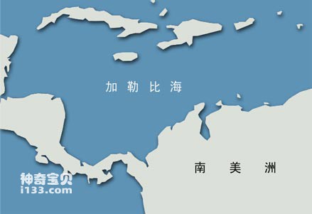
Caribbean geographical location map
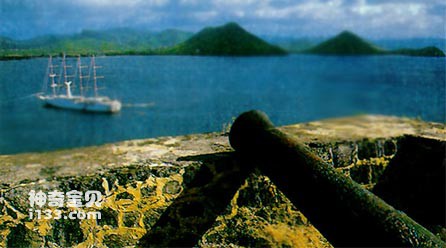
On the coast of St. Lucia in the Caribbean, there are still forts from the colonial wars.
The zigzag curved coastline of Central and South America divides this area into several major waters: the Gulf of Honduras off the coast of Guatemala and Honduras; Mosquito Bay near the coast of Panama; the Panama Canal near Colon, Panama; Panama and Colombia The Gulf of Darien on the border; the Gulf of Venezuela outside the mouth of Lake Maracaibo in northern Venezuela; and the Gulf of Paria between Venezuela and Trinidad. Most rivers in Central America flow into the Caribbean Sea, but most rivers in South America join the Orinoco River and flow into the Atlantic Ocean just south of Port of Spain. The main imports and exports of the Caribbean Sea are the Yucatan Strait between Yucatan and Cuba, the Windward Channel between Cuba and Hispaniola, and the Mona Strait between Hispaniola and Puerto Rico. , Anegada Strait between the Virgin Islands and Martin Strait, and the Dominican Strait north of Dominica Island. The water depth in each strait is more than 1,000 meters.
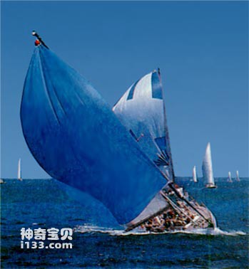
Sailing on the Caribbean Sea
The Caribbean Sea basin is separated by several ridges, making the basins and trenches staggered. The northernmost Yucatan Basin has a water depth of about 5,000 meters. It is bounded by the 220-kilometer-wide Yucatan Strait to the north and separated by the Cayman Ridge and Cayman Trench in the south. This ridge reaches directly from Cuba to the coast of Central America, and the Cayman Islands are exposed to the east of it. The Cayman Trench is quite narrow and contains the Caribbean Sea's maximum water depth (7,100 meters). Further south, there is the wider wedge-shaped Nicaragua Rise, which separates the trench from the Columbia Basin, and the island of Jamaica sits on this rise. The Colombian Basin is 3,666 meters deep and is connected to the Venezuelan Basin. Further east is the North Venezuela Trench. But westward from Hispaniola, the Beata Ridge separates the Colombian Basin from the Venezuelan Basin. The water depth of the Venezuelan Sea Basin is 5058 meters, and it is adjacent to the narrow and curved Aves Rise.
animal tags:
We created this article in conjunction with AI technology, then made sure it was fact-checked and edited by a Animals Top editor.
you may also like

The Dardanelles Strait is located on the west side of the northwest corner of Turkey. It is an important channel connecting the Sea of Marmara and the Aegean Sea. The total length of the strait is 71 kilometers, the narrowest point is only 1.3 kilometers, the widest is 7.5 kilometers, and the...

The Thousand-Year Snapper is very tall, with medium-sized comb scales, and all the scales above and below the lateral line run diagonally. The snout is blunt and pointed, and the dorsal edge is straight. The front end of the upper jaw has 2 pairs of large conical teeth, and the lower jaw has...

In the history of the United Nations, a total of three conferences on the law of the sea have been held so far. The first time was held in Geneva from February 24 to April 27, 1958; the second time was held in Geneva from March 17 to April 26, 1960; and the third time was from December 3, 197...

Salmon (Oncorhynchus keta) is a fish that lives in seawater and belongs to the family Salmonidae. They spend most of their life cycle primarily in the ocean before migrating back to freshwater areas to lay their eggs. The following is a detailed introduction to salmon:Life History: Salmon are a migr...

The great blue-ringed octopus (scientific name: Hapalochlaena lunulata) is a species of octopus in the genus Blue-ringed octopus. Although it is called a "big" blue-ringed octopus, it is actually not that big, with its tentacles not exceeding 10 centimeters, and weighing about 80 grams. It is...

Sirenian mammals (Order Sirenia) are a group of marine placental mammals with only four living species today. Their name comes from the mythical “sirens” or mermaids, since early sailors often mistook female sirenians nursing their young for human-like figures in the sea. In reality, mermaids neve...

The long-billed red eagle's snout is long and pointed, in the shape of a needle-nose pliers. The body is slender and silvery white. The side of the body is evenly distributed with red stripes vertically and horizontally, in a red grid shape. Body length 60mm. Distribution: Tropical Indian and...

The common name of French crappie: French crappie. The kiss stands out. The front rays of the dorsal and anal fins are long filaments. The body is dark brown with several yellow arc stripes and golden yellow between the scales. There is a yellow spot at the base of the pectoral fin. Caudal fi...
Email: jsset668#gmail.com (change # to @) Please indicate your purpose of visit! Guangdong ICP No. 2022053326 XML| map| Chinese
