The Gulf of Alaska is located in the northeastern corner of the North Pacific and the northwest side of the North American continent. It covers an area of 1.327 million square kilometers, a volume of 3.226 million cubic kilometers, a maximum depth of 5,659 meters, and an average depth of 2,431 meters.
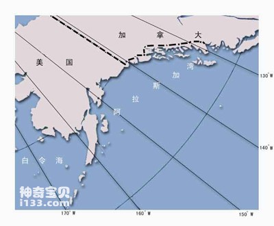
1. Geographic location map of the Gulf of Alaska
2. Gulf of Guinea
The Gulf of Guinea is located on the Atlantic side of central Africa, bordering Gabon, Equatorial Guinea, and Cameroon to the east, and Nigeria, Benin, Togo, Ghana, Ivory Coast and other countries to the north. It covers an area of 1.533 million square kilometers, a volume of 4.592 million cubic kilometers, and an average depth of 2996 meters. , the maximum depth is 6363 meters.
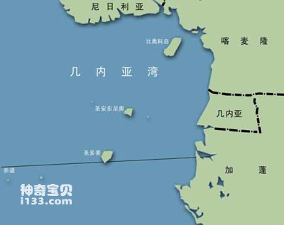
Geographic location map of the Gulf of Guinea
Along the Gulf of Guinea, the vast areas on the north and south sides of the tropical rainforest climate have a savanna climate. Although the East African Plateau is located near the equator, it has a higher altitude and does not have the conditions to form a tropical rainforest, so it also has a savanna climate. Tropical desert climates are distributed near the Tropic of Cancer on both sides of the savanna climate, except that the tropical desert climate range in the south is narrow. The Mediterranean climate is also small in scope, confined to the southernmost coastal areas. The climate throughout Africa is symmetrically distributed from north to south with the equator as the central axis.
The savannah climate is distributed on both sides of the tropical rainforest climate zone in the western and central parts of the continent. The year is divided into two obvious dry and wet seasons: in the wet season, wind blows from the sea and there is abundant precipitation. The grass on the savanna can grow up to 2 meters high, and the branches and leaves on the trees are tender green, which can meet the needs of herbivorous animals such as zebras, giraffes, and antelopes on the grasslands. This is also the season when carnivores such as lions and leopards are most active. In cultivated savanna areas, if rainfall is timely and sufficient during the wet season, good harvests can be obtained in the fields.
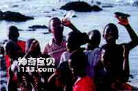
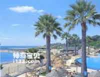
Black children on the seaside of Guinea
In the dry season, under the control of subtropical high pressure, it is dry and rainless. The tall grass on the savanna is mostly scorched, yellowed and withered, leaving only scattered low grasses. All the leaves on the trees have fallen off. Wild animals have moved in groups to places with water and grass, making field farming difficult. In some years, the dry season is prolonged, or there are droughts for several consecutive years, leading to famines.
Sub-Saharan Africa is very rich in mineral resources, with many types and large reserves, many of which occupy an important position in the world. The reserves and production of gold and diamonds rank first in the world. There are also large reserves of copper, iron ore, uranium ore and other metal minerals. In the world, South Africa is the country that produces the most gold, Guinea is the country that produces the most bauxite, and Zambia is an important country that produces copper mines. Although the oil resources in this area are not as rich as those in West Asia and North Africa, the oil reserves in the coastal areas of the Gulf of Guinea are also considerable. Nigeria is an important oil producer in the region.
3. Bay of Biscay
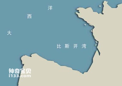
Geographic location map of the Bay of Biscay
The Bay of Biscay is located in the northeastern part of the North Atlantic Ocean, bordering France to the east and Spain to the south. It covers an area of 194,000 square kilometers, a total volume of about 332,000 cubic kilometers, an average depth of 1,715 meters, and a maximum depth of 5,120 meters.
The coast of the Bay of Biscay
The Bay of Biscay is one of the most special and attractive coastlines in Spain, because its coast is lined with continuous cliffs. Like elegant port towns, their coasts are set against a beautiful backdrop of nature. The unique local architectural style and pleasant climate radiate brilliant green on the horizon. This makes the Basque coast, as well as Cantabria, Asturias and Galicia, another popular summer holiday destination in Spain. Surrounded by the clear Mediterranean Sea, the Balearic Islands show their unique island style. Cliffs, ecological reserves and beaches where you can fully enjoy the sun, as well as complete leisure and entertainment facilities, are harmoniously dotted on the island's special topography.
animal tags:
We created this article in conjunction with AI technology, then made sure it was fact-checked and edited by a Animals Top editor.
you may also like

Penguins are a special group of birds that live in Antarctica and surrounding areas. They have many characteristics that allow them to adapt to extreme environments. The following is a detailed introduction to the characteristics and life characteristics of penguins: phys...

Bigger has advantages, at least in ancient oceans. Professor Marc Laflamme from the University of Toronto Mississauga campus explained why ancient organisms tended to become larger. For early multicellular organisms, size was really a huge advantage. In order to apply NASA's Space Institute r...

Between 430 and 345 million years ago, intense orogeny occurred in the earth's crust. The sea surface shrank, land appeared widely, and the climate became dry and hot. Cretaceous marine biomes During the ebb and flow of sea water, some algae slowly adapt to life...

Under the blue sea, colorful "stone flowers" bloom. Colorful tropical fish happily shuttle back and forth among the stone flowers, roaming up and down. Clusters of red, green, and white "stone flowers" complement each other with schools of red and purple fish. This is both a beautiful and mov...

Bicolor damselfish. The vomer and jaw bones have teeth. The lateral line is interrupted, the upper lateral line is almost close to the dorsal edge of the body, and the lower lateral line extends to the base of the tail. The front half of the body is purple and the back half is yellow. Body le...

The side of the body of the Forked Butterflyfish is flat and high. The kiss is short. The body is weakly lamellar and the lateral line is incomplete. There is a black horizontal band on the head, and there are many brown vertical stripes along the body side. There are often bifurcations at th...

The vaquita (Phocoena sinus), also known as the “little sea cow” or “cochito,” is the rarest marine mammal in the world and one of the most endangered. Endemic to the northern part of the Gulf of California, Mexico, the vaquita’s population has plummeted in recent decades. Today, it is estimate...
")
Between northern Africa and the Arabian Peninsula, there is a bright red sea. This is the Red Sea. It is a subsidiary sea of the Indian Ocean. The Red Sea is like a crocodile with its mouth wide open, lying diagonally from northeast to southeast. It is about 2,000 kilometers long, with a maxi...
Email: jsset668#gmail.com (change # to @) Please indicate your purpose of visit! Guangdong ICP No. 2022053326 XML| map| Chinese
