In the vast expanse of blue waves in the south of the motherland, Hainan Island, the second largest island in our country, lies. It is separated from the Leizhou Peninsula at the southern tip of the mainland by only one water, and between them is the Qiongzhou Strait, which is about 20 kilometers wide. Standing at the southern tip of Leizhou Peninsula and looking south, you can clearly see the jade-like land of Hainan Island.
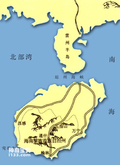
Hainan Island geographical location map
Hainan Island's long axis runs north, southeast and west, about 300 kilometers long, and its short axis is about 180 kilometers wide. Its surface shape is like Sydney, with an area of about 34,000 square kilometers and a coastline of 1,618 kilometers.
As early as more than 2,000 years ago, my country's Western Han Dynasty set up counties and counties on Hainan Island, called Zhuya, and began to manage this ancient land. In the Song Dynasty more than 1,000 years ago, Hainan began to be called Hainan, and it continues to be used today. Hainan Island was established as a province in April 1988, referred to as Qiong. In addition to the main island and surrounding islands, it also has jurisdiction over the Xisha Islands, Zhongsha Islands and Nansha Islands in the South China Sea.
Hainan Island is the second largest island among the mainland islands in my country. It has an inseparable "mother-child relationship" and the same geological structure as the South China mainland. It is an island formed by faulting after the earth's crust rose.
During the Early Paleozoic Era (570 million years ago to 440 million years ago), the Leizhou Peninsula and Hainan Island were a subsidence zone. The Caledonian orogeny caused the Leiqiong area to rise into land, forming a series of fault fold belts mainly in the northeast direction, which caused qualitative changes in the strata deposited in the Early Paleozoic. By the late Paleozoic (440 million years ago to 230 million years ago), the Hainan Island landmass was relatively stable. However, the Indosinian movement also promoted strong magma activity, forming the granite bodies that are now widely distributed in Hainan Island, forming mountains and forming the foundation of Hainan Island. Later, the Yanshan Movement and the Himalayan Movement caused strong fractures in this granite dome, forming several large east-west fault zones, which raised about two-thirds of the area south of the faults, called the Hainan Tectonic Uplift, and more than 100 million people It has been rising since years; a subsidence occurred to the north of the fault, called the Leiqiong Sag. However, before the Quaternary Period (2.5 million years ago), Hainan Island and Leizhou Peninsula were still connected together, and were an extension of the Cathaysia block in terms of geological structure. Around the middle of the Pleistocene (2.5 million years ago to 15,000 years ago), due to volcanic activity, a fault occurred between Leizhou Peninsula and Hainan Island, forming the Qiongzhou Strait, which separated Hainan Island from the mainland. After that, the sea level rose and fell many times, causing Hainan Island to be separated and connected to the mainland many times. By the end of the Quaternary Ice Age, the sea level had risen significantly, and the current shape of the Qiongzhou Strait and Hainan Island was formed.
The Hainan tectonic uplift caused by geological tectonic movements caused the central part of Hainan Island to continuously rise, gradually forming the current landform characteristics of Hainan Island; mountains are located in the center, and hills, terraces, and plains are surrounding it in sequence. The average altitude of Hainan Island is 20 meters. Mountains above 500 meters account for 25% of the island, and plains and platforms above 100 meters account for two-thirds.
Hainan Island is located south of the Tropic of Cancer and has a tropical monsoon ocean climate. It is hot and rainy all year round, with long summers and no winter. The annual average temperature is 22 to 27 degrees Celsius. It is extremely rich in tropical resources and is known as the treasure house of tropical resources in my country. Tropical crops here, such as rubber, oil palm, pepper, banana, coconut, etc., are abundant and evergreen all year round.
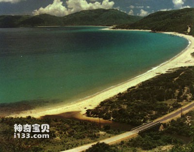
The Wanquan River originates from the Nanling of Linbei Village in Wuzhishan Mountain and enters the sea at Bobie Port. It has a total length of 162 kilometers and a drainage area of 3,683 square kilometers. The photo shows the downstream surface of the Wanquan River.
Wuzhishan is the symbol of Hainan Island. It is located in Qiongzhong County in the east of central Hainan Island. It is the highest mountain in Hainan Island. The entire mountain is made of granite. Long-term strong erosion has caused the mountain to undulate in a jagged shape, forming five peaks arranged in sequence, like five fingers, hence the name. Wuzhi Mountain is a scenic spot on Hainan Island and one of the famous mountains on the southern coast of my country.
animal tags:
We created this article in conjunction with AI technology, then made sure it was fact-checked and edited by a Animals Top editor.
you may also like

Penguins are a special group of birds that live in Antarctica and surrounding areas. They have many characteristics that allow them to adapt to extreme environments. The following is a detailed introduction to the characteristics and life characteristics of penguins: phys...
")
In the coral reefs of the South China Sea, where there are many corals, there live some fish with flat sides, degraded abdomen, about 20 centimeters in length, and an appearance that resembles the pufferfish (skinned fish). Because their whole body is covered with hard plate-like thick scales...

The tentacled lionfish has a large mouth. The pectoral and dorsal fin spines are very long and the fin membranes are deeply split. The pectoral fin membrane is fan-shaped and has brown spots. Horizontal banding, no longitudinal banding on the caudal peduncle. Body length 20 cm. Distribution a...

What category of animals do sharks belong to? A comprehensive analysis of the classification and characteristics of sharksSharks are one of the most awe-inspiring predators in the ocean, and their ferocity and unique appearance have aroused widespread interest. As a species that has survived on Eart...

Chrysanthemums on land bloom in autumn, but in the vast ocean, there are "sea chrysanthemums" that bloom all year round. They are sea anemones. Sea anemones come in many shapes, with thousands of species, generally cylindrical in shape, with bright colors, and their bases attached to rocks, s...
")
Humpback whales (also known as gray whales) and killer whales are both marine mammals, each with unique characteristics and survival skills. Here is a detailed introduction and comparison of these two species of whales:Humpback whale (gray whale):Features:Humpback whales are medium-sized large whale...

The suction cup formed by the first dorsal fin on the back of the fish head is longer and has 22 to 26 pairs of cartilage plates in horizontal rows. The second dorsal node is as long as the anal fin base and has 35 to 40 fin rays. The caudal fin is pointed in juvenile fish and gradually becom...

In front of the dorsal line of the white-striped sawfish, there is a broad milky-white band surrounded by a narrow black edge that extends diagonally downward, passing through the posterior edge of the eye and reaching the back of the interopercular bone. It is a small warm-water fish that li...
Email: jsset668#gmail.com (change # to @) Please indicate your purpose of visit! Guangdong ICP No. 2022053326 XML| map| Chinese
