Between Taiwan Province and Fujian Province in my country, there is a broad waterway running from northeast to southwest. It is the largest strait in my country. Because it is close to Taiwan, the largest island in my country, people call it the Taiwan Strait. The Taiwan Strait runs through the southeastern coast of my country. It goes north from the South China Sea, or goes south from the Bohai, Yellow Sea, and East China Sea. It must pass through here. It is commonly known as my country's "maritime corridor."
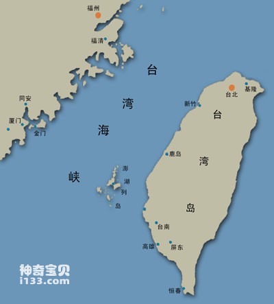
Diagram of the Taiwan Strait
The Taiwan Strait also has international navigation value. Maritime exchanges between Northeast Asian countries, Southeast Asian countries, and countries along the Indian Ocean can easily pass through here. However, the Taiwan Strait is under the jurisdiction of my country. According to the provisions of the United Nations Convention on the Law of the Sea, foreign ships passing here must implement innocent passage and must not affect my country's peace and security, nor damage the life and labor order of our people.
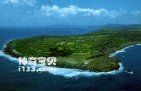
Kenting, Taiwan, has the sound of mountains and seas and the beauty of swamps.
The northern end of the Taiwan Strait is bounded by the line connecting Pingtan Island in Fujian Province to Fuguijiao in the northern end of Taiwan, and its southern end is bounded by the line connecting Nan'ao Island in Guangdong to Eluanbi in the southern end of Taiwan. It is about 300 kilometers long from north to south and 170 kilometers wide from east to west, covering an area of more than 60,000 square kilometers.
The Taiwan Strait has experienced many vicissitudes of life during its long geological period. About 70 million years ago, the Taiwan Strait was still a trough on the edge of the ancient Chinese continent. By 40 million years ago, affected by the Himalayan orogeny, this area rose from a trough to become land, and Taiwan Island was connected to the mainland. At that time, the Channel area was a plain. Since then, the channel area has sometimes risen and sometimes been divided by water. About 15,000 years ago, our country was in the Dali Ice Age. Glaciers expanded, sea levels dropped, and the strait turned into land again, with lush weeds and forests, and herds of cattle, horses, and sheep everywhere. Mammoths also come here to look for food. This situation lasted about 5,000 years. About 10,000 years ago, the climate warmed again, the glaciers melted, the sea level rose again, and the strait changed from a grassland with "wind-blown grass and low cattle and sheep" to a fish and shrimp An ocean of joy to swim in. To this day, it’s still rough.
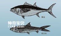
The Taiwan Strait is one of the important fishing grounds in my country. Tuna and milkfish are one of the main fisheries in the Taiwan Strait.
The landforms across the Taiwan Strait are quite different. The west coast is mostly rocky coast with many twists and turns, bays, cliffs, strange rocks and peaks, sea caves and headlands, and densely populated islands. Fujian Province has more than 30 large and small harbors and more than 600 islands. The east coast of the strait is mostly sandy shore, with a relatively straight coastline, relatively low terrain, obvious siltation of the beach, deep water areas far away from the shore, and few natural harbors. Rivers flowing down from Taiwan's mountains carry large amounts of sediment into the sea, forming coastal alluvial plains that continue to expand toward the strait. At present, Taiwan's crust is still in a period of slow rising, and the land area of Taiwan Island is gradually expanding.
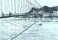
In the mountainous areas of Taiwan, cable bridges like this across valleys can be seen everywhere.
The Taiwan Strait is in a subtropical climate zone. The northwest is more affected by the continental and coastal cold currents, while the southeast is more affected by the ocean and the Taiwan warm current. In winter, the temperature across the strait is lower than on both sides, and the temperature on the east coast is higher than that on the west coast. The average temperature is about 15°C; in summer, the temperature is higher, reaching 28°C. The wind and waves in the Taiwan Strait are relatively strong, especially in the winter half of the year, when the northerly monsoon is strong and strong winds blow almost every three days; strong winds blow up huge waves, as high as 6-9 meters. In summer, the wind is mostly southerly and the wind force is small, and the strait is relatively stable. But in July and August, typhoons are prevalent. When a typhoon passes through here, it will bring heavy rain, huge waves and storm surges. If there happens to be an astronomical tide, the water level along the coast will rise sharply, which can seriously threaten the safety of people's lives and property. About half of the typhoons that land in my country will hit the Taiwan Strait and both sides of the Taiwan Strait.
The Taiwan Strait is rich in resources. Warm and cold water flows meet here, water exchange is smooth, and there are many kinds of fish and shrimp. It is one of the important fishing grounds in my country. The main fisheries are: bream, shark, squid, snapper, tuna, mullet, milkfish, etc. Among them, bream, tuna and shark are the three major fisheries here. Tuna weighs an average of more than 50 kilograms each. It tastes great and can be eaten raw. There are many artificially cultured oysters and milkfish on both sides of the Taiwan Strait. According to legend, after Zheng Chenggong regained Taiwan, he advocated raising milkfish. This kind of fish can reach more than 1 meter in length, has white flesh and delicious taste. The current breeding area is approximately one million acres. In addition, various shellfish and algae are cultivated on both sides of the Taiwan Strait, among which Xiaowo in Lianjiang County is the famous hometown of clams. There are also many Gelidium, seaweed, asparagus, etc. here, especially Gelidium from the Penghu Islands is the most famous. The seaweed from Haitan Island is the best.
The bottom of the strait is rich in oil and gas resources. It is estimated that it covers an area of about 20,000 square kilometers. It is a promising prospect area. There are also minerals such as titanium, magnet, rutile, monazite and zircon, with high grades and large reserves.
animal tags:
We created this article in conjunction with AI technology, then made sure it was fact-checked and edited by a Animals Top editor.
you may also like

Common name of round-winged swallowfish: red bat. The front parts of the dorsal and anal fin rays are extended, and the ventral fins are also extended. The dorsal edge of the head and fin edges are orange-red. Body length 300mm. Distribution: South China Sea, Taiwan, Red Sea, tropical Indian...

Shoulder-ringed crappie has multiple annular bands on its side and small blue rings on its shoulders. The dorsal fin has 12 sharp spines. There are serrations on the edge of the opercular bone, and there is a strong spine at the corner. The abdominal knot and anal fin both have strong spines....

Common name of Spotted Pepper Snapper: Butterfly Bass. The dorsal fin has deep notches between spines and rays. Juvenile fish and adult fish have different body colors. The head and body of the adult fish have brown spots on a white background. Body length 60 cm.Mainly distributed in the Nansha Isla...

The coast where reeds, rice grass, saltwort and other plants grow is called the reed and halophyte coast. The characteristics of these plants are that they can live in salt water and are salt-alkali resistant. In early spring, new buds sprout, dyeing the coast into emerald green. In late autu...

Commonly known as sharks or selachians, the cartilaginous fish that belong to the superorder Selachimorpha are among the most fascinating and extensively studied marine animals. Their advanced predatory abilities and remarkable cognitive capabilities have made them a subject of deep interest to scie...

Dugong There is a kind of sea beast called dugong living along the coasts of Guangdong, Guangxi, Taiwan and other provinces in my country. Its name is a direct transliteration of Malay, and some people also call it "Southern Sea Cow". In addition to China, dugongs are also distributed in s...

The common name of the two-color thornfish is: Stone Beauty. There is a blue-black band between the eyes on the side of the head. The front part of the body is yellow, the back part is blue, and the tail is yellow. Body length 12 cm. Distribution area: South China Sea, Ta...

Are there any hot springs under the sea now? What do hot springs under the sea look like? In the past 20 years, after repeated investigations by scientists, they have discovered that there are hot springs at the bottom of the ocean, but it is a pity that ordinary people cannot see them. Only...
Email: jsset668#gmail.com (change # to @) Please indicate your purpose of visit! Guangdong ICP No. 2022053326 XML| map| Chinese
-Animals Top")