In the northwest of the South China Sea in my country, there is a large, semi-enclosed bay called Beibu Gulf. It is bounded by my country's Leizhou Peninsula and Hainan Island to the east, my country's Guangxi Autonomous Region to the north, Vietnam to the west, and connected to the South China Sea to the south. It covers an area of nearly 130,000 square kilometers, slightly larger than the Bohai Sea. The average water depth is 40 meters, with the deepest reaching 100 meters. Beibu Gulf is the closest access to the sea in the southwestern region of my country.
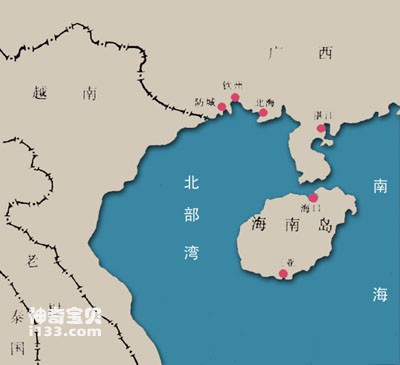
Geographical location map of Beibu Gulf
The seabed of Beibu Gulf is relatively simple, gradually descending from the top of the bay to the mouth of the bay. The seabed is relatively flat, and the sediment brought from the land is deposited on it. There are many mangroves in the coastal estuary areas.
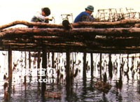
Hepu pearl oyster culture
Beibu Gulf is located in the tropics and subtropics. In winter, it is affected by cold air from the continent, with strong northeasterly winds, and the sea surface temperature is about 20°C. In summer, the wind comes from the tropical ocean, with strong southwesterly winds, and the sea surface temperature is as high as 30°C. It is often hit by typhoons. Generally, about 5 typhoons pass through here every year.
The sea currents in the Beibu Gulf turn counterclockwise in winter. The water in the outer sea goes north along the east side of the bay, and the water in the bay goes south along the west side of the bay, forming a circulation. In summer, driven by the southwest monsoon, the sea currents form in the opposite direction. circulation. Here, the tide rises and falls only once in a day, which is called a diurnal tide. The tidal range of rising and falling gradually increases from the mouth of the bay to the top of the bay. In the waters near the North Sea, the maximum tidal range can reach 7 meters. The current flows back and forth along the coast. This is called a reciprocating current.
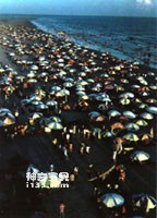
Guangxi Beihai seaside
The Beibu Gulf is rich in resources. It is rich in more than 50 kinds of economically valuable fish such as snapper, golden thread fish, sardines, jackfish, blue trevally, tuna, flounder, pomfret, and mackerel. It is one of the excellent fishing grounds in my country. one. Shellfish include oysters, pearl oysters, sun and moon clams, mud clams, clams, etc. Weizhou Island, Yinggehai and other seabed oil and gas resources are also considerable.
my country’s port cities Beihai, Qinzhou, Fangcheng, etc., located on the shores of the Beibu Gulf, are all important port cities. Hepu County now belongs to Beihai City, as early as 2000 years ago. It is famous for its pearl fishing industry. During the Hongwu period of the Ming Dynasty, there was a "White Dragon" Pearl City in Yingpan Township, southwest of Hepu. Zhucheng is more than 300 meters long from north to south and more than 200 meters wide from east to west. It is built with masonry walls and is about 6 meters high. There is an observation deck on the city gate, where you can see the situation of pearl mining and transportation from far and near. There are yamen such as the Pearl Mining Eunuch's Mansion, the Pearl Field Inspection Department and the Salt Transport Envoy in the city, which are specially used to supervise and purchase pearls and pay tribute to the emperor and ministers. . It can be seen that the pearl fishing industry was already very developed at that time. In the Hepu area of Beihai, pearl fishing is the main source of livelihood for local people. The pearls here are of excellent quality and are famous far and wide.
animal tags:
We created this article in conjunction with AI technology, then made sure it was fact-checked and edited by a Animals Top editor.
you may also like
")
The Indian Ocean is between Asia, Africa, Oceania and Antarctica. It is the third largest ocean in the world, with a total area of 74.917 million square kilometers, about 1/5 of the total ocean area. Its average depth is 3897 meters and the deepest is 7729 meters. The northern part of the Ind...

Whip butterfly fish. Common name: Black-rumped butterfly. The fourth ray of the dorsal fin is extended in a filamentous shape. There is a large oval blue-black spot on the back and upper part of the body. The lower edge of the spot has a wide white edge and the rear edge is orange-red. There...
: Characteristics, Habitat, and Feeding Explained")
The world’s oceans harbor a vast diversity of extraordinary and often little-known creatures. Among them are the Sea Pens (also called Sea Feathers), marine animals belonging to the order Pennatulacea. These relatives of corals and jellyfish have stunning and unique appearances, sometimes even kept...
")
In the coral reefs of the South China Sea, where there are many corals, there live some fish with flat sides, degraded abdomen, about 20 centimeters in length, and an appearance that resembles the pufferfish (skinned fish). Because their whole body is covered with hard plate-like thick scales...

The common name of boxfish is horn. The head and body armor are pentagonal, with a pair of preorbital spines and lumbar spines. The tail fin has purple-blue round spots. Body armor yellow-green. Body length 56 cm. Distribution areas: South China Sea, East China Sea, Yellow Sea, Red Sea, East...

The continental shelf is a natural extension of the continent. The slope is generally small and there are not many fluctuations. The total area of the world's continental shelves is approximately more than 27 million square kilometers, with an average width of approximately 75 kilometers, acc...
")
The Wandering Albatross is the largest flying crow in Antarctica and the king of flying birds in the world. It is covered in pure white feathers with black markings on its tail and wing tips. Its body is streamlined. When it spreads its wings and flies, the distance between the wing tips can...

Under the blue sea, colorful "stone flowers" bloom. Colorful tropical fish happily shuttle back and forth among the stone flowers, roaming up and down. Clusters of red, green, and white "stone flowers" complement each other with schools of red and purple fish. This is both a beautiful and mov...
Email: jsset668#gmail.com (change # to @) Please indicate your purpose of visit! Guangdong ICP No. 2022053326 XML| map| Chinese
-Animals Top")