Located on the northern edge of the Pacific Ocean, surrounded by Alaska, Siberia and the Aleutian Islands. It is generally accepted that the northern boundary is the North Pole and the Chukchi Sea, but a more accurate northern boundary should be the narrowest mouth of the Bering Sea. The southern part is defined as the line connecting Cape Capuchi on the Alaska Peninsula, through the Aleutian Islands, to the southern tip of the Commando Islands, and then to Cape Kamchatka. This includes all waters between Alaska and Kamchatka. The total area of the Bering Sea is 2.304 million square kilometers, the average water depth is 1,598 meters, the total volume is 3.683 million cubic kilometers, and the maximum water depth is 4,420 meters.
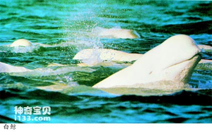
Beluga whale in the Bering Sea
There is evidence that the first person to explore the Bering Sea was the Russian Cossack S. Dezhnev. According to reports, in 1648, Dezhnev and a small team set out from the mouth of the Kolyma River in the East Siberian Sea, sailed eastward, rounded the Eastern Cape (Dezhnev Cape), passed through the Bering Strait, sailed into the Bering Sea, and West to the mouth of the Anadyr River at the southern tip of the Chukotka Peninsula. Of course, the Bering Sea is named after the Danish sailing explorer v. Named after Bering. During the Great Northern Expedition of 1724-1749, he served in the Russian Navy. In 1728, Bering left his temporary working area in the Sea of Okhotsk and sailed across the Bering Sea, heading north through the Bering Strait and into the southern Chukchi Sea. In 1778, J. Captain Cook sailed north on the "Resolution" and passed through the Bering Strait, becoming the first person to cross the Arctic Circle and the Antarctic Circle.
The seafloor of the Bering Sea can be divided into two areas. The northeastern half is entirely a continental shelf, one of the largest continental shelves in the world. The furthest distance offshore can reach 643 kilometers. In the area extending to the Chukchi Sea through the Bering Strait, the continental shelf is shallower than 200 meters, so the seawater flowing into the Arctic basin is limited to surface water. The second area is the southwestern half, consisting of deep water basins with a maximum depth of 4,420 meters. The seabed of the ocean basin is very flat, with water depths ranging from 3800 to 3900 meters, and is separated by two ridges. The Olivotsky Ridge starts from the north and runs through the entire ocean basin; the other is the unique Rat Island Ridge, which starts from the Aleutian Island Arc and goes around the basin in a counterclockwise direction. These two ridges divide the deep water area into two ocean basins, east and west. Within this deep sea basin, there is also a sedimentary sea basin that sediments quickly; this sea basin is covered with 2000-4000 meters of sediment on basalt bedrock.
The Bering Shelf also raised several islands from the flat seafloor, including the famous St. Lawrence Island, Nunivak Island and Pribilof Islands. The edge of the shelf dips steeply downward at a gradient of 4° to 5°. In the southeast corner of the Aleutian island chain, the continental shelf is deeply divided by the Bering Canyon, which is more than 161 kilometers long and 32 kilometers wide. It is deeply cut and has more than 50 branch valleys. This may be the largest underwater canyon in the world. On both sides of the canyon, there are 1,829-meter-high valley walls everywhere, standing on the gently sloping (0.5°) seabed. The sediments of the Bering Shelf are composed of sand and gravel deposited on the foothills. In contrast, deep-sea basins are covered with diatom ooze.
The temperature of the Bering Sea is -25℃ in winter and 10℃ in summer. In winter, sea ice freezes 90% of the sea area, but in summer it is completely ice-free.
The currents in the Bering Sea are caused by wind. The sea is fed by Pacific water from the Aleutian island chain. Currents and fresh water flowing in from rivers. The current pattern in the deep ocean basin is mainly cyclonic circulation. Part of it flows northward through the Bering Strait, and the other part flows back into the Pacific Ocean. The ocean currents on the continental shelf are basically affected by tides, except for the Alaskan coast. Fresh water from many rivers flows northward through the Bering Strait into the Chukchi Sea.
The Bering Sea is very rich in marine life. Plankton has two peak growing seasons, one in the spring and the other in the fall. They are mainly diatoms, which provide the basic guarantee for the food chain. What makes the Bering Sea a valuable fishing ground are mainly cancer crabs, shrimps and 315 species of fish. In particular, 25 species of fish are more economically valuable, such as: killer whales, beluga whales, beaked whales, black baleen whales, fin whales, Cetaceans such as right whales, boom whales and sperm whales are abundant. However, affected by various factors such as the deterioration of the marine environment, whales have become a rare species on the earth. Environmental groups such as the International Whaling Commission (IWC) have been strongly calling on governments around the world to enact regulations to ban the killing of whales. Although Japan, Norway and other countries are still hunting whales in an organized manner, many governments, including China, have clearly implemented legal protection for whales. The Pribilof and Comandor Islands are breeding grounds for seals and are home to numerous sea otters, sea lions and walruses.
animal tags:
We created this article in conjunction with AI technology, then made sure it was fact-checked and edited by a Animals Top editor.
you may also like

The Strait of Gibraltar is located between southernmost Spain and northwest Africa. It is an important gateway connecting the Mediterranean Sea and the Atlantic Ocean, with a total length of about 90 kilometers. The narrowest point of the gorge is only 14 kilometers, and the widest point wher...

A coast with a large number of jade-like stones piled up and down the tidal flats is called a pebble coast. Pebbles vary in size, ranging from larger than goose eggs, similar to eggs, to smaller than quail eggs. The garden degrees of pebbles are also different, including muddy garden, oval ga...

Common name of black double sawfish: saddleback clown. Body tan. There is a wide white horizontal band on the back edge of the eye, and a second white horizontal band on the side of the body extends to the edge of the last spine and fin ray of the dorsal fin, forming a saddle-back shape. Body...

On the southern coast of the Mediterranean Sea, there is a place called Tunisia. In the nearby Madia Sea area, 40 meters underwater, many marble columns were found buried in the mud. According to historians, they are cultural relics from 2,000 years ago. After the discovery was announced, Aus...

Four-banded horsefish. Common name: Huaguandao. The fourth fin spine of the dorsal fin is significantly extended and takes the shape of a long whip. There are four colored horizontal bands on the sides of the head and body. The dorsal fin and caudal fin are orange-yellow. Body length 25 cm. D...

Sharks are an ancient and fascinating marine species with powerful carnivorous and swimming abilities. The following is a detailed introduction to the living habits of sharks: 1. Habitat: Widely distributed: Sharks live in all oceans an...

Peru is located on the southeast coast of the Pacific Ocean, with a coastline of more than 2,200 kilometers. The coast of Peru is a famous fishing ground in the world. In the 1950s, Peru's fishery output reached hundreds of thousands of tons. After 1962, the fishery developed even faster, wit...

Commonly known as sharks or selachians, the cartilaginous fish that belong to the superorder Selachimorpha are among the most fascinating and extensively studied marine animals. Their advanced predatory abilities and remarkable cognitive capabilities have made them a subject of deep interest to scie...
Email: jsset668#gmail.com (change # to @) Please indicate your purpose of visit! Guangdong ICP No. 2022053326 XML| map| Chinese
