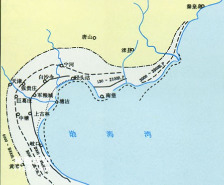
On the west bank of Bohai Bay, the shell embankment along the coast of Huanghua City, Hebei Province is famous far and wide. In recent decades, Huanghua Shell Bank has been an important object of research by scientists. Huanghua Shell Dike in Bohai Bay consists of 6 shell embankments. The six shell banks are all parallel to the modern coastline, representing coastal locations in different eras. Scientists named the six shell embankments No. 1, No. 2, No. 3, No. 4, No. 5 and No. 6 shell embankments from west to east according to their distance from the sea.
Schematic diagram of Bohai Sea coast changes
Shell banks are formed by the hard shells of dead shellfish living in the intertidal zone that are transported by waves and accumulated near the high tide line. Huanghua No. 1 shell embankment was formed between 6150 and 5340 years ago. It took 810 years from the beginning to the end of development. During these 810 years, the embankment was the coastline at that time. During this period, no large rivers entered the sea here, and the seawater had high transparency and was suitable for shellfish. The shells left over after a large number of shellfish died were accumulated near the high tide line under the action of waves, forming Shell Bank No. 1.
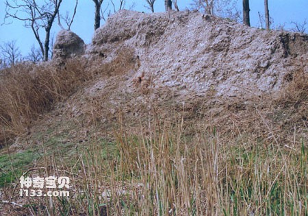
The remains of ancient shells can be seen everywhere in Dagang
After 5340 years ago, due to the Yellow River entering the sea nearby, the sea water became turbid, the sediment was deposited into land, and the coastline stretched forward, thus the No. 1 shell embankment was abandoned on high land.
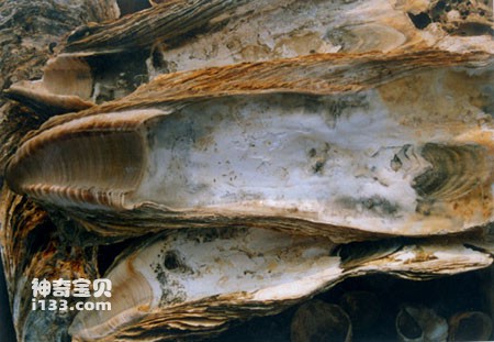
Ancient mother-of-pearl remains (about 2,000 years ago)
Due to the diversion of the Yellow River, the amount of sediment entering the sea has been drastically reduced, the sea water has been clarified, siltation has stopped, the coastline has stabilized, and shellfish have multiplied in large numbers. Under the action of waves, a new shell embankment has been formed, namely Huanghua No. 2 Shell Embankment. Shell Dike No. 2 was formed between 4740 and 3955 years ago and is 15 kilometers away from Dike No. 1. The formation of the embankment took about 785 years.
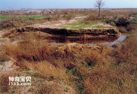
Tianjin Dagang Ancient Coast Site
The reason for the formation of Huanghua Shell Embankment is roughly the same. For more than 6,000 years, the mouth of the Yellow River has oscillated between the Bohai Sea and the Yellow Sea. The six shell embankments along Huanghua's coast are all products of the sea and the Yellow River. The six shell embankments running parallel from east to west are like six brothers standing in a row. The No. 1 embankment, which is the farthest to the west and farthest from the shore, is the eldest among these brothers and has been in existence for 6150 years. The easternmost embankment No. 6 is still flooded at high tide and exposed at low tide. It was only formed 1030 years ago. The two are 30 kilometers apart and 5,120 years apart in age. The six shell embankments show that since 6150 years ago, the Huanghua coastline has been undergoing drastic changes from west to east. Shellfish remains can be used to determine geological age. Shell banks are faithful records of coastal changes and sea level changes and are of great scientific value. Shell embankments also have a bank protection role and have certain economic value. Shell sand can be used as building materials and feed additives. In recent years, the Huanghua Shell Embankment has been over-developed. In order to protect the Shell Embankment from damage, the local government has established the Shell Embankment Nature Reserve. <br>
animal tags:
We created this article in conjunction with AI technology, then made sure it was fact-checked and edited by a Animals Top editor.
you may also like

Peru is located on the southeast coast of the Pacific Ocean, with a coastline of more than 2,200 kilometers. The coast of Peru is a famous fishing ground in the world. In the 1950s, Peru's fishery output reached hundreds of thousands of tons. After 1962, the fishery developed even faster, wit...

There are bright red spiny starfish and huge bread starfish in the ocean; there are also beautiful shell-shaped sea urchins with purple-red bodies and beautiful patterns on their petal-like spines. Their spines are thick and vary greatly in color. Making cigarette holders, it is also called "...
")
People have a pulse, and doctors can diagnose the patient's condition through changes in the pulse phase. The sea also has a pulse. Whenever you see the sea, you will always see it undulating there. The ups and downs of the waves are so much like the beating of human pulse! According to the "...

Hairy fish has flat sides and a protruding abdomen. The body is covered with fine villi-like spines. big head. The gill openings are small and located below the base of the arm-like pectoral fins. The top of the first dorsal fin spine is a spherical spike, forming a snout tentacle; there is a...

Warm seawater near the equator flows to the Arctic and Antarctic seas through circulation, and cold polar water flows to the equatorial seas through circulation, forming the circulation of the world's oceans. Ocean circulation is an important factor in maintaining the earth's heat balance. Th...

The mouth of the fish is very flat on the sides. The snout is very long and tubular. Mouth small, anterior position. The two jaws are shaped like the ends of tweezers, forming a straight cleft. The spine of the dorsal fin is high and has 12-13 spines. The pectoral fins are long and sickle-sha...

An old navigator once said: "The islands in the ocean are like the stars in the sky, no one can count them." This sentence describes the large number of islands in the world. So far, how many islands are there in the oceans around the world? It's hard to tell an exact number. Some people say...

Whip butterfly fish. Common name: Black-rumped butterfly. The fourth ray of the dorsal fin is extended in a filamentous shape. There is a large oval blue-black spot on the back and upper part of the body. The lower edge of the spot has a wide white edge and the rear edge is orange-red. There...
Email: jsset668#gmail.com (change # to @) Please indicate your purpose of visit! Guangdong ICP No. 2022053326 XML| map| Chinese
