A bay in the eastern Atlantic Ocean, bordered partly by England and Scotland to the west, Norway, Denmark, the Federal Republic of Germany, the Netherlands, Belgium and France to the east, and from the Voorde Lighthouse on the French coast to the south across the Strait of Dover. It is bounded by the line joining Leather Point on the British coast; in the north it starts from Dunnet Point in Scotland, through Orkney and the Shetland Islands, then along the longitude 0°53′ west to 61° north latitude, and then along 61° north latitude The line connecting the latitude eastward to the coast of Norway is the boundary. The southern part of the North Sea is connected to the Atlantic Ocean through the Strait of Dover; the northern part is connected to the Atlantic Ocean and the Norwegian Sea through the gap between Scotland and Norway; the eastern part is connected to the Skagerrak and Kattegat Straits between Norway, Sweden and Denmark. , connected to the Baltic Sea. The North Sea is about 965 kilometers long and 580 kilometers wide in the north. The total area is 600,000 square kilometers, the average water depth is 91 meters, and the volume is 155,000 cubic kilometers. Several islands in this sea area cover a total area of 73 square kilometers.
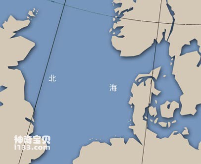
Beihai geographical location map
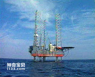
An oil platform built in the North Sea area
The North Sea is considered a continental sea, that is, its entire structural sea basin is on the continental (opposite of oceanic) crust. The ocean basin is, in part, a geosyncline (the location of a long sedimentary deposit) that was folded into mountain ranges at least twice in the past. Each time, these mountains were washed away, leaving only a shallow basin between England and the mainland. About 230 million years ago, the land around the North Sea was desert. Due to high evaporation and limited water inflow from the north, huge evaporite deposits were formed. Now, the salt domes and structures found on the seafloor of the North Sea and in Germany and Denmark are representatives of these evaporites. The history of the formation of submarine structures in the North Sea is directly related to the vast oil fields currently being developed in the North Sea and neighboring countries.
Of course, the bottom of the North Sea is a continental shelf. The southern half of the sea is a sea platform with a water depth of 40 meters. The seafloor gradually slopes northward, reaching a depth of about 183 meters at the edge of the continental shelf west of the Shetland Islands. Around the southern tip of Norway to beyond the edge of the continental shelf is a rare strait (Norwegian Strait) with a depth of about 600 meters. Some oceanographers believe that the valley was formed by continental glaciers. There are also other remnants of the last glacial period (11,000 to 8,000 years ago), which are valley-like cuts left over when sea levels were low and glacial moraines (the so-called glacial ice feed means that when glaciers melt, sediments are deposited on the glacier front accumulation). The Dogger Sandbank between the UK and Denmark is an example, with water depths of only 13 meters. The seabed sediments are mainly glacial gravel, sand and silt. Among them, powdery sand can be found everywhere. This is because it is re-transported by currents and waves.
The water circulation in the North Sea is affected by both Atlantic water from the north and Baltic water from the east, while very little water flows in from the Strait of Dover in the south. Most of the water comes from the North Atlantic Current, which flows south along the coast of Orkney and the Shetland Islands. After reaching the south, it turns counterclockwise and flows out along the coast of Norway to become the Baltic Sea Current. The surface water temperature ranges from 2 to 7°C in February and from 11 to 17°C in August. Salinity varies with region and season. Due to the large amount of fresh water flowing into the continental rivers (Rhine, Elbe, Weser, Ems and Scheldt), coastal waters in Norway, Denmark, the Netherlands and Germany are frozen even if they are not too cold in winter. In the west, there is less fresh water entering the sea and is affected by the North Atlantic current, so there is no ice even in severe winter.
The tides in the North Sea are more complicated, because the smaller partial tide moves northward from the Strait of Dover, and the larger partial tide enters from the estuary between Scotland and Norway and propagates southward. The tidal range is 7 meters along the coast of England and 1.5 meters in the vast open sea. Storms that hit the North Sea from the northwest often cause considerable damage to the 6,436-kilometer-long coast. If this kind of disaster is combined with a storm surge, when large waves and high tides occur at the same time, the damage to coastal areas will be more serious, especially to the protective coast of the Netherlands.
The North Sea is one of the largest fishing grounds in the world, accounting for half of the world's fresh fish production. The coastal people of nearby countries rely on fishery as their main industry. In 1958, the North Sea seabed was divided into several oil and gas exploration and development areas by the United Kingdom, the Netherlands, Germany, Denmark and Norway. The first natural gas well and oil well were put into production in 1959 and 1969 respectively. The North Sea has proven oil reserves of 23 billion barrels, making it the ninth largest oil field in the world.
animal tags:
We created this article in conjunction with AI technology, then made sure it was fact-checked and edited by a Animals Top editor.
you may also like

Between 430 and 345 million years ago, intense orogeny occurred in the earth's crust. The sea surface shrank, land appeared widely, and the climate became dry and hot. Cretaceous marine biomes During the ebb and flow of sea water, some algae slowly adapt to life...

The common name of flame spiny fish is: Shining Fairy. The posterior horn of the preopercular bone has a strong posterior spine. The body is bright red with 6 black horizontal bands. Body length 6 cm. Distribution area: Pacific tropical waters....

Thin-spined fish has flat sides and is covered with tiny scales. The head is small, the mouth is small, and the snout is slightly pointed. The teeth in both jaws are small. The operculum membrane heals and is not connected to the isthmus. The body is yellow with 5-6 stripes. The fin membrane...

Melon-headed whale alias: multi-toothed melon-headed whale. Morphological characteristics: The head is oval, without a rostrum, with a pointed front end, and the upper jaw does not protrude from the lower jaw. The dorsal fin is located in the middle of the body, wider than that of the false k...

Octopus and cuttlefish are both cephalopods and they have many similarities, but also some differences. The following is a detailed introduction to octopus and squid, including their characteristics, living habits and ecological roles:Octopus:Features: Octopus has a cylindrical body, eight tentacles...

Sharks are an ancient and fascinating marine species with powerful carnivorous and swimming abilities. The following is a detailed introduction to the living habits of sharks: 1. Habitat: Widely distributed: Sharks live in all oceans an...

The evolutionary history of vertebrate animals begins with curious organisms that might not resemble typical animals at first glance—yet they are indeed animals. These are sea squirts. Though small and sedentary, often just a few centimeters in size, sea squirts hold critical evolutionary clues tha...

People may not be familiar with black sea bream, but as long as they say "black sea bream", it is a household name among coastal residents. This fish has an elegant body and bright color, with black markings on its sparkling body. Black sea bream has delicious meat and rich nutrition. It is a...
Email: jsset668#gmail.com (change # to @) Please indicate your purpose of visit! Guangdong ICP No. 2022053326 XML| map| Chinese
