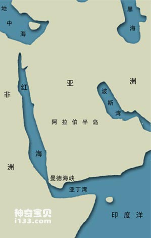
Between northern Africa and the Arabian Peninsula, there is a bright red sea. This is the Red Sea. It is a subsidiary sea of the Indian Ocean. The Red Sea is like a crocodile with its mouth wide open, lying diagonally from northeast to southeast. It is about 2,000 kilometers long, with a maximum width of 306 kilometers and an area of about 450,000 square kilometers. The northern section is connected to the Mediterranean Sea through the Suez Canal, and the southern end is connected to the Gulf of Aden through the Bab el-Mandeb Strait. The red algae in the sea will multiply seasonally, turning the entire seawater into reddish brown. Sometimes even the sky and coast are reflected in bright red. It is so impressive to people that it is called the Red Sea. In fact, under normal circumstances, the water of theRed Seais blue-green.

Schematic diagram of the location of the Red Sea
After the opening of the Suez Canal in 1869, the Red Sea became a key thoroughfare between the Indian Ocean and the Mediterranean Sea and an important international shipping route; it shortened the original route around the Cape of Good Hope by 9,000 kilometers.
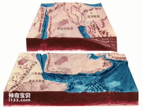
The Red Sea is a young sea. About 20 million years ago, the Arabian Peninsula separated from Africa, giving birth to the Red Sea. It can still be seen that the shapes of the two sides of the Taiwan Strait are very similar, which is the trace left by the continent being torn apart. The rift between the African and Arabian plates passes through the middle of the Red Sea. In the past 3 to 4 million years, the two plates have continued to divide, with the two sides of the Taiwan Strait expanding outward at an average rate of 2.2 centimeters per year. The Red Sea is constantly widening and may become a new ocean in the future.

The geometric discontinuity of the coastlines on both sides of the Afar Triangle on the edge of the Red Sea illustrates the problem. About 25 million years ago, today's Yemen happened to fit between Raubiya and Somalia. After the central expansion and separation, the crustal fragments on both sides of the present-day Danakil horst were formed, becoming the Afar Triangle region.
In 1947, the Swedish research ship "Albatross" visited the Red Sea for investigation and discovered several heat sources in the seafloor rift. Later, the American "Atlantis II" and the British "Discoverer" also came here to investigate one after another, confirming the existence of these heat sources, and measured the water temperature here as high as 56°C, and the salinity as high as 74-310. Under normal circumstances, the water temperature of tropical sea surface is generally only 30℃ at the highest, and the deep water temperature is generally only 4℃. The salinity of seawater is generally around 35. In the rift valley of the Red Sea, the water temperature is more than ten times higher and the salinity is 2-9 times higher, which is really surprising.

The Arabian Peninsula may be one of the smallest plates on Earth. It moves northeastward, and you can see in this area typical features of plate tectonics such as ocean expansion, corresponding coastlines on both sides, central rift valleys, and fold mountain systems.
Why does such an abnormal situation occur? Scientists believe that due to the continuous expansion of rifts, lava from the mantle flows out and heats the seawater seeping down along the cracks; a large amount of minerals and dissolved salts also take the opportunity to dissolve into the seawater. . These hot seawaters are rich in polymetallic minerals such as iron, manganese, zinc and lead. People call them hydrothermal deposits. After the investigation results were announced, they attracted world attention; the Sudanese government first proposed the ownership of these seabed minerals. But it is not easy to mine these minerals under 2,000 meters of water, so it is still just talk on paper.
The Red Sea is in a tropical desert climate zone. The annual rainfall in the north is only 28 mm, which is really pitiful, and in the south it is only 127 mm. Every drop of water is as expensive as oil. However, the evaporation here is very large, with an annual average of about 2100 mm, which is much greater than the precipitation. In addition, there are no rivers flowing into the Red Sea, so the Red Sea cannot make ends meet. It must be replenished by the flow of water from the Indian Ocean; the Gulf of Aden becomes a "big reservoir" that regulates the level of the Red Sea. The water entering the Gulf of Aden from the Indian Ocean makes its way northward and enters the thirsty Red Sea, replenishing its water shortage. The high temperature and high salt water in the Red Sea also continue to flow through the bottom of the Bab el-Mandab Strait to the Gulf of Aden, becoming an important source of high temperature and high salt water in the Indian Ocean.
animal tags:
We created this article in conjunction with AI technology, then made sure it was fact-checked and edited by a Animals Top editor.